What is a wind rose?
A wind rose is a circular display of how wind speed and direction are distributed at a given location for a certain time period. Wind roses on our site are generated by the Colorado Avalanche Information Center.

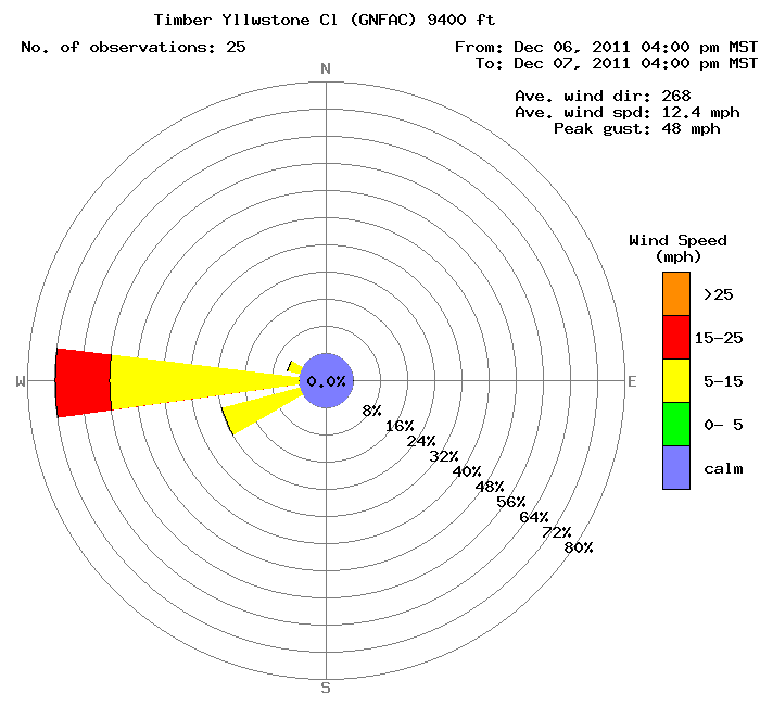
Below is a sample wind rose from December 6th - 7th from the Timber Weather Station
How do I read it?
The header identifies the weather station. In the example above, it is the Timber station at the Yellowstone Club. It displays the last 25 hours of data covering the date and time range shown on the upper right. A summary of average wind direction, average wind speed, and peak gust is given on the right as well.
The most important data is displayed by each "spoke." The length of each "spoke" tells the frequency of wind coming from a particular direction. In this case 72% of the given time (25 hrs), winds blew from the W. 24% of that time, winds blew from the WSW.
To determine wind speed frequency is a little more difficult. Wind speeds are indicated by color. If a "spoke" is mostly one color, then winds blew mostly at the wind speed denoted by that color. In this case, 56% of the time, winds blew from the W at 5-15 mph. For the red section of the "spoke" which indicates winds at 15-25, you have to do a little math. The red section is between 72% and 56%. Subtract these two numbers and you get 16%. This means winds blew from the W at 15-25 mph for 16% of the time.
The circle in the center indicates calm winds. Winds were calm 0% of the time.
For a detailed description of wind roses by the NRCS and a page from which this description was based click here.