Good Morning. This is Doug Chabot with the Gallatin National Forest Avalanche Forecast issued on Wednesday, December 12th at 7:00 a.m. Today’s forecast is sponsored by Alpine Orthopedics and Community Food Co-op. This forecast does not apply to operating ski areas.
Last night Lionhead received 4” of snow, the southern Madison Range got 1” and Cooke City received 2". Around Bozeman and Big Sky winds are blowing west-southwest at 25-30 mph with gusts of 60 mph. Temperatures are in the 20s F. Near West Yellowstone and Cooke City winds are west at 10-15 mph with gusts of 30 mph and temperatures near 10 F. This morning 1-2” will fall and winds will continue to be strong into the evening. Skies will clear this afternoon and temperatures will drop into the teens tonight.

Eric was in Lionhead yesterday and found the snowpack to be wanting. It’s shallow (under 2 feet deep), weak (the bottom half are sugary facets), and unstable on anything wind-loaded (stability tests all propagated). Seeing is believing and his video and photo illustrate the terrible snowpack structure. Last night’s 4” of snow (.2” of snow water equivalent) and west winds will create dangerous avalanche conditions. Cracking and collapsing of the snowpack as you ride or ski are signs of unstable snow. Avalanches may run on the ground and break wide across the slope. Today the avalanche danger is rated CONSIDERABLE on all wind-loaded slopes and MODERATE on all others.

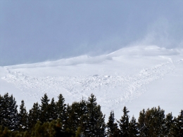
Yesterday’s 4” of new snow was blown onto many slopes and into gullies. I toured into Mt. Blackmore in Hyalite and was able to watch the wind-loading trigger a couple avalanches off the ridge and on the east face (photo 1, photo 2, video, report). Nearby, ice climbers reported heavy drifting in the gullies that scared them off. South of Cooke City a skier triggered a small (6” x 20’) wind slab (report) and ski patrols reported touchy wind slabs that did not propagate far.
The wind will be strong today, but without new snow there is not much left to blow around. Slopes with a wind-load should be approached cautiously. I did not venture onto anything steep and wind-loaded yesterday, nor would I today. Rethink your travel plans if you get shooting cracks or collapsing. For today, the avalanche danger is rated MODERATE on all wind-loaded terrain since avalanches are possible. On slopes without a wind-load, the danger is LOW.
If you get out and have any avalanche or snowpack observations to share, contact us via our website, email (mtavalanche@gmail.com), phone (406-587-6984), or Instagram (#gnfacobs).
Upcoming Avalanche Education and Events
Our education calendar is full of awareness lectures and field courses. Check it out: Events and Education Calendar.
BOZEMAN
TONIGHT! December 12, 1-hr Avalanche Awareness for Snowmobilers, 6-7 p.m. at Yellowstone Motorsports, Bozeman.
December 13, 1-hr Avalanche Awareness, 7-8 p.m. at Play It Again Sports, Bozeman.
HELENA
TONIGHT! December 12, 1-hr Avalanche Awareness, 6-7 p.m. at The Basecamp, Helena.
COOKE CITY
Every Friday and Saturday, Rescue Training and Snowpack Update. Friday 6:30-7:30 p.m. at the Soda Butte Lodge. Saturday anytime between 10-2 @ Round Lake.
Check out our new “Avalanches and Snowpits” menu item where we list all the reported avalanche activity.