Photos
|
Bridger Range, 2021-12-23 On December 23, 2021 we went out to Saddle Peak and dug three snowpits. We found a 2-3 foot deep, generally stable snowpack with a lack of unstable buried weak layers. Photo: GNFAC |

|
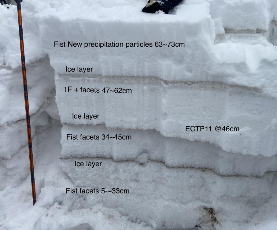
Northern Gallatin, 2021-12-22 Pit from 12/22/21 at 9,850' on the NE face/shoulder of Mt. Blackmore. Snow depth was 111cm, first ECT was ECTN10 below the wind slab then ECTN22 on facets at 70cm. A second test was ECTN17 on that facet layer, then ECTP20 on depth hoar at 35cm. A third ECT was ECTP17 on the facets at 70cm, then a fourth ECT was another ECTP17.... I was moving into shallower snow as I got more unstable results, down to about 90cm HS. These weak layers are not easy to trigger or showing obvious signs of instability, but we will need to be careful when we get more snow, especially during large cumulative loading or big wind events. Photo: GNFAC |
|
Northern Gallatin, 2021-12-22 North face of Mt. Blackmore on 12/22/21. South-southwest winds were moderate-strong and scouring more than loading it seemed like, but isolated slabs and whales of snow could be found. We did not get any drifts to crack or collapse. Fresh wind slabs were 2-4" thick, 1f-P hard, and not very continuous. Photo: GNFAC |
|
Southern Madison, 2021-12-22 Bare ground on the ridge between Tepee Basin and Bacon Rind Creek. Nearby we found 4 ft deep drifts. 12/22/21. Photo: GNFAC |
|
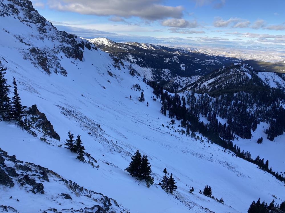
Southern Madison, 2021-12-22 An avalanche in Tepee Basin appears to have failed within or under the new snow around 12/15/21. Photo taken 12/22/21. Photo: GNFAC Link to Avalanche Details |
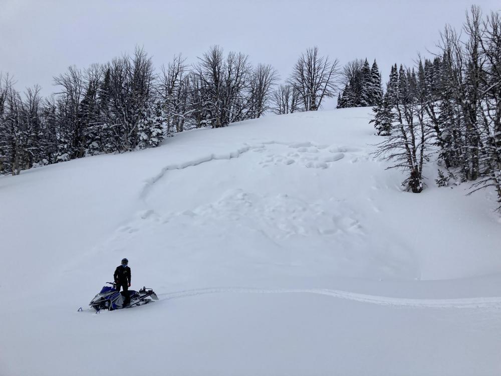
|
Southern Madison, 2021-12-22 An avalanche in Tepee Basin that broke under new snow on facets near the ground. Likely occurred on 12/15/21. Photo taken 12/22/21. Photo: GNFAC Link to Avalanche Details |

|
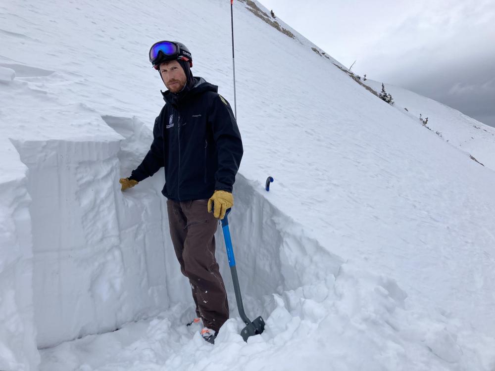
Southern Madison, 2021-12-22 Digging a snowpit in 4 feet of drifted snow in Tepee Basin (12/22/21). Photo: GNFAC |
|
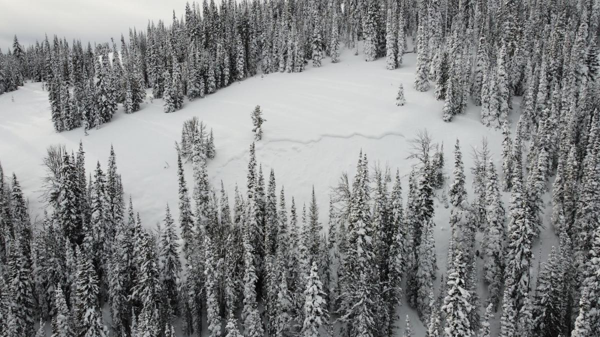
Lionhead Range, 2021-12-22 Riders in the Lionhead area observed 5-6 naturally occurring avalanches that likely failed on 12/15 at the tail end of a 3' snowstorm. Photo: S. Tyson Link to Avalanche Details |
|
Cooke City, 2021-12-21 From Beartooth Powder Guides: Saw this small natural avalanche today while coming back from the yurt. While being small on the relativity scale, it seems to have broke fairly deep. Link to Avalanche Details |
|
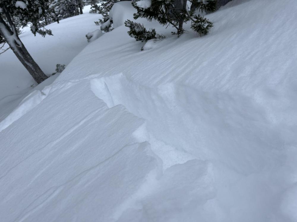
Cooke City, 2021-12-20 We generally stayed away from wind-loaded slopes today in Cooke City; however, we triggered this crack while crossing through a large drift of snow on Scotch Bonnet. This is an indicator of issues we will find on wind-loaded slopes right now. Photo: GNFAC |
|
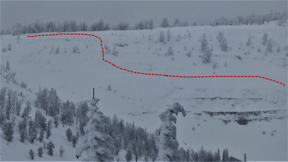
Lionhead Range, 2021-12-20 Located off Lionhead Ridge outside West Yellowstone, this natural avalanche likely released after the large storm ended Wednesday, December 15. This slope is SE facing and the crown is about 9,400 feet. Faceted snow at/near the ground was the likely weak layer that avalanched. Photo: GNFAC Link to Avalanche Details |
|
Cooke City, 2021-12-20 New snow in Cooke City on December 20th. Photo: GNFAC |
|
Bridger Range, 2021-12-19 Cornices that formed mid-slope, indicating recent heavy wind-loading in the Bridger Range. Strong southwest wind between 12/18 and 12/19/21 drifted recent snow into hard, pillowy drifts. We avoided these drifts on steep slopes to give them a day or two to stabilize. Photo: GNFAC |
|
Bridger Range, 2021-12-19 These pillowy, hard drifts formed from strong southwest wind overnight between 12/18 and 12/19/21 in the Bridger Range. We saw minimal signs of instability, lke whumphing or cracking in these drifts, but avoided these features on steep slopes until they have more time to gain stability. Photo: GNFAC |
|
Cooke City, 2021-12-19 In shallow areas near rock bands and wind-scoured slopes, we found a more developed weak layer of depth hoar. These shallow areas will be areas of concern when they get loaded by a larger storm or wind event. Photo: GNFAC |
|
Northern Gallatin, 2021-12-19 From obs 12/18/21: "95cm Snow depth at around 9400’ 40cm of new snow on early December ice crust Ectx18 Will have to see with more loading on early December interface if it becomes reactive All alpine terrain was heavily stripped from the wind." |
|
Cooke City, 2021-12-18 Cooke City Beacon Checker. Photo: R. Youngbar |
|
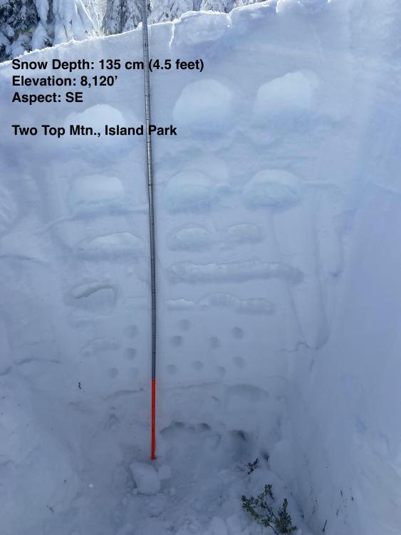
Island Park, 2021-12-17 Snowpack on Two Top Mtn. near Island Park, ID on 12/17/21. More than 3 feet of snow fell last week and it was right side up and generally stable. There is some weak snow and crusts near the ground, but we are not seeing signs that these layers are unstable yet. Photo: E. Knoff |
|
Northern Madison, 2021-12-17 From obs: "On the way up on the West facing ridge we found facets to the ground below 17cm with that large ice layer on top. Given the low density of the new snow sitting on top, we ascended to Bear Basin-Middle Ridge via the ridge and lower angle gully. Photo is taken at 2860m, East facing on the ridge between Beehive Basin and Middle basin. Layers in the photo are easily distinguishable in the photo. We decided not to ski into Middle Basin and descended back the way we came up. On the ridge winds were blowing East ~15mph and cornices were present. Wind loading to the East looked visible to the eye by the lumps in the snow." Photo: "T. Hoefler" |
|
Bridger Range, 2021-12-16 On 12/16/21 A skier in a group of three triggered and was caught in this avalanche next to The Apron at Bridger Bowl. The ski area is closed and backcountry conditions exist. Nobody was injured. From e-mail: "We had a group of three skiing up at the Bridger Apron today. We skied a more main slope in the field north of the slope with hidden couloir, snow was very stable and has been getting a lot of tracks. For a second run we skinned up the main slope under hidden and started our run in the trees slightly south of this slope. Not many tracks over there and not a good enough evaluation of the snowpack. We were planning on skiing a northeast facing chute through the trees that had very nice looking snow similar to what we had skiied earlier. I skiied in and had about 3 amazing turns, definitely partially due to the wind loading at this aspect. After three turns my feet were taking out from under me and I got caught in a slide keeping skis perpendicular to slope for 15-20’. This avalanche carried me rapidly and cleared the snow to the rocks below in which I was able to come to a hault and watch the rest of the sluff slide past me. After looking at the conditions after, this windy aspect seemed to have a very faceted layer about 8” down that acted as the crown. No injuries, a lost ski pole in the runout which extended down the slope maybe another 40’. The wind scoop on top and seeing these facets should have been a clear sign prior to skiing. Must be more diligent even in areas of high traffic. When dropping in to ski on first turn or so I remember hearing a possible whumpf." Link to Avalanche Details |