Good morning. This is Dave Zinn with the Gallatin National Forest Avalanche Forecast on Thursday, December 7th at 7:00 a.m. This information is sponsored by the Bozeman Ice Festival, Alpine Orthopedics & Sports Medicine, and Stronghold Fabrication. This forecast does not apply to operating ski areas.
Bridger Bowl is opening the lower mountain Friday through Sunday. Uphill travel is permitted from a backcountry gate at the top of the Sunnyside Quad. Backcountry conditions exist above the Quad with no avalanche mitigation or ski patrol services. Call 911 for rescue.
Mountain temperatures are in the 20s to 30s F with 15-30 mph winds from the west to southwest. Snow began this morning with 1-3” in the mountains around Big Sky, West Yellowstone, Island Park and Cooke City. Today, high temperatures will be in the 20s to mid-30s F with 15-25 mph winds from the west to southwest. The mountains around West Yellowstone, Island Park and Cooke City will receive 8-10” of snow by tomorrow morning, with 4-6” in the mountains around Big Sky and Bozeman.

Dangerous avalanche conditions exist in the southern portions of the advisory area where a slab of cohesive snow sits on top of a weak foundation of sugary facets. Snowfall throughout the day will make conditions more dangerous. Slopes with wind-drifted snow are most likely to avalanche, but all are suspect.
In the past week, evidence of the danger included human-triggered and natural avalanches, shooting cracks, and whumphing collapses. On Sunday near West Yellowstone, a splitboarder had a close call on Lionhead Ridge while I made a video outlining the instability (avalanche details, video). Sledders from nearby in Island Park sent observations of natural avalanches and shooting cracks in Black Canyon (details, details 2). On Monday, riders in the Taylor Fork observed several avalanches and triggered two slides from one hundred feet away (details and photo). In Cooke City, the weak foundation of faceted snow couldn’t support last weekend’s storm avalanching naturally on some slopes (details and photos 1, 2). On Tuesday, Alex and Ian triggered loud whumphs that told them conditions remained unstable (video).
Do not let the thin snow cover fool you. There is enough snow to avalanche, bury and injure skiers, riders and climbers. Avoid slopes steeper than 30 degrees as human-triggered avalanches are likely. The danger is rated CONSIDERABLE.

Human-triggered avalanches large enough to bury or injure climbers, skiers or riders are possible in the northern portions of the advisory area. Today, new and wind-drifted snow will further prime slopes with a weak foundation for avalanches.
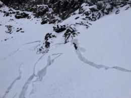
Groups will swarm to the gullies of Hyalite Canyon for this weekend’s Bozeman Ice Fest. Consider the locations of parties uphill and downhill of your group. On Monday, a climber in the Dribbles area observed cracking across the slope (observation and photo). Gullies funnel small avalanches into concentrated blasts that can knock people off their feet in consequential terrain.
In Big Sky, Alex made a video showing a weak snowpack last week. Big Sky Ski Patrol’s snow safety team notes that the area’s snowpack is still weakening. During avalanche mitigation work on wind-loaded slopes, they have triggered several hard slab avalanches (photo).
Before considering steeper terrain, assess the snowpack for instability. Watch for signs of recent avalanches, shooting cracks or collapsing, and dig a snowpit to test for less obvious instability. Remember the adage, “If you are on a slope with enough snow to ski or ride, there is enough snow to slide.” The avalanche danger is rated MODERATE.
Dangerous avalanche conditions exist in Island Park where a slab of cohesive snow sits on top of a weak foundation of sugary facets. Snowfall throughout the day will make conditions more dangerous. Slopes with wind-drifted snow are most likely to avalanche, but all are suspect. Avoid slopes steeper than 30 degrees, as human-triggered avalanches are likely.
The avalanche danger is CONSIDERABLE.
Please fill out an observation form after your backcountry day. It does not need to be technical. Did you see any avalanches? How much snow is on the ground? Was the wind moving snow? Simple observations are incredibly valuable. You can also contact us via email (mtavalanche@gmail.com), phone (406-587-6984), or Instagram (#gnfacobs).
Upcoming Avalanche Education and Events
Our education calendar is full of awareness lectures and field courses. Check it out: Events and Education Calendar.
Tuesday, December 9th, 9:00 a.m. to 3:00 p.m., West Yellowstone Motorized Avalanche Fundamentals, Pre-registration and more information HERE.
We offer Avalanche Fundamentals with Field Session courses targeted towards non-motorized users in December and January and one geared towards motorized users in January. Sign up early before they fill up.
Loss in the Outdoors, is a support group for those who have been affected by grief and loss related to outdoor pursuits. Check out the link for more information.
Listen to GNFAC Forecaster Dave Zinn on the Hoary Marmot Podcast for some extracurricular avalanche talk (link to episode).