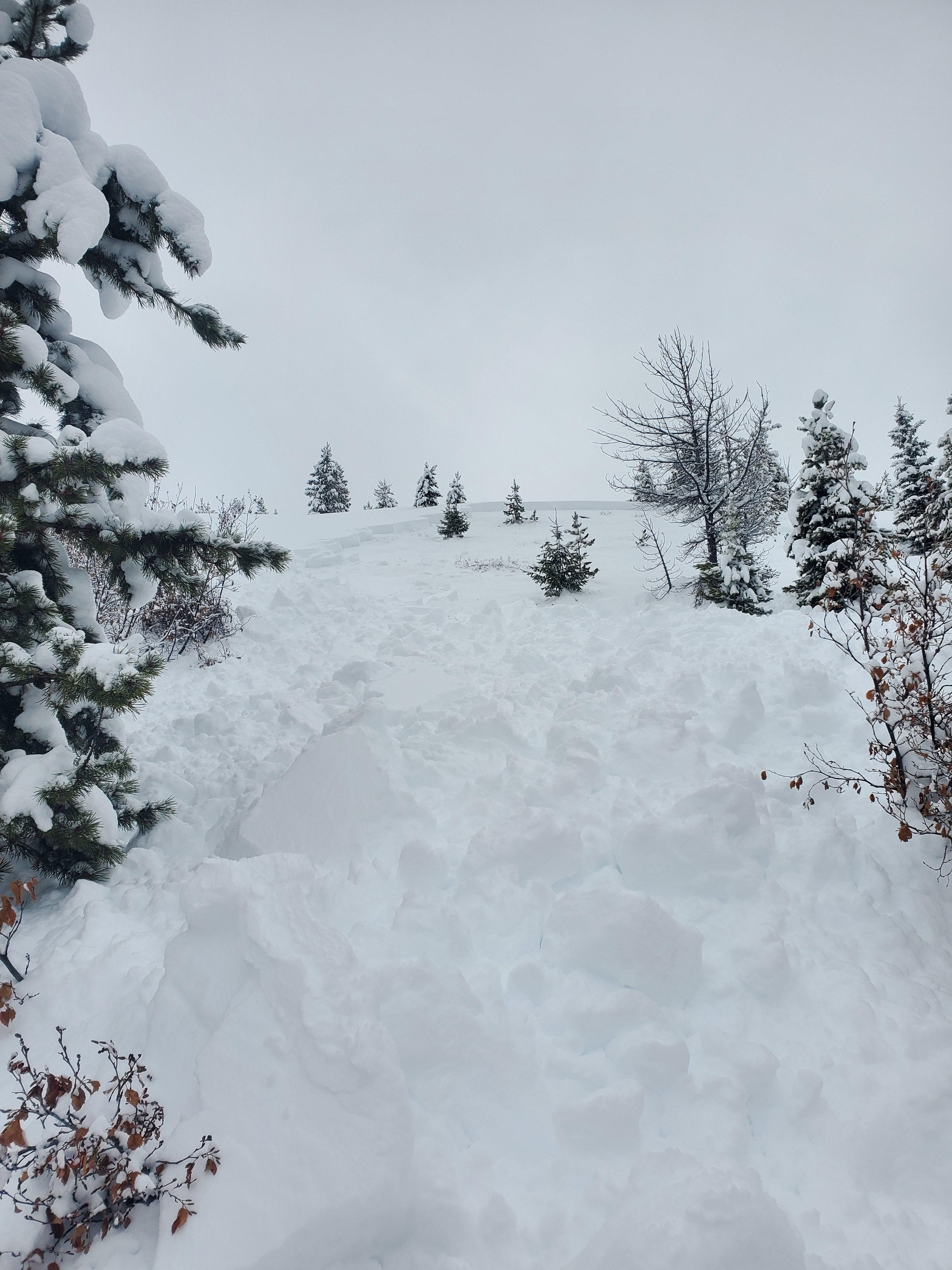
Trip Planning for Butte Area

6384′     03-19 01:22
38℉
Wind 4 mph
Gusts 6 mph
7180′     03/19 at 00:00
34℉
20″ Depth
7889′     03-19 01:22
35℉
Wind 2 mph
Gusts 4 mph
7800′     03/19 at 00:00
30℉
47″ Depth

Snow Observations-Butte Area

W. Shoutis
Butte Area
Flint Creek Range
Snowmobile triggered avalanche Twin Peaks
Snow Obsdrvation includes images

Secondhand photo and story regarding two snowmobilers sidehilling the northwest aspect of Twin Peaks and triggering the slide in the photos.  They were both able to ride out of it.  This avalanche is located about 150 yards north of the Twin Peaks avalanche accident site from January 2024.

Full Snow Observation Report
W. Harden
Butte Area
Red Mountain
Mid mountain, cross loaded natural release
Snow Obsdrvation includes images

North facing, cross loaded, mid-mountain slope on an east to west running rib at around 9,600'.  Typically this zone is scoured by W-SW winds.  Mild to moderate winds and new snow of 10-12" sitting on an exceptionally weak base produced a natural release during the recent storm cycle, possibly early AM 2/15/24. The slide appeared to run full track, 800' +, taking out most of the north facing wall.

Full Snow Observation Report
W. Shoutis - BDNF
Butte Area
Flint Creek Range
Avalanche accident on Twin Peaks
Snow Obsdrvation includes images

2 Snowmobilers riding into the Twin Peaks area, and one decided to sidehill a slope with patchy larch trees that is 42 degrees at the top, and consistently windloaded.  The resulting avalanche took him and his sled approximately 300 feet downhill to a patch of small diameter larch trees where the trees formed a fence that strained the rider and his sled and also piled up the debris.  It was likely one of these small trees that broke the victim's leg.  They were very familiar with the area, and all the previous accidents (one fatality occurred north of this spot by 150 yds, and several full and partial burials have occurred along this ridge) that have happened in that area.  They were carrying all rescue gear and airbags(victim did not deploy his airbag).  One of the riders was at an avalanche class I put on at the toe of the slope 5 years ago.  There was no real hazard evaluation, and the riders did not observe any signs of instability prior to triggering the avalanche. Once the rider sidehilled into the open everything fractured above him in the windslab.  My partner and I had several large collapses assessing the area, and the victim's riding partner stated that they had several collapses moving the victim to the helicopter.  The helicopter landed very close to the toe of the slope.  The snow depth at the crown was 60 inches deep, with one wind slab sitting on another on facets, and at the toe of the slope the snow depth was less than 20 inches deep.  The fracture traveled roughly 800 feet in and around the larch trees near the top of the slope and it deposited debris in 3 different run outs.

Victim was buried vertically with a boot sticking out, and his riding partner exposed his face in 2 minutes.  He extricated his whole body in 8-10.  He had a broken femur and a broken hand.  As they were digging, rescuers stated that the second leg wasn't vertical, and they found it at an oblique angle to the rest of the body.  They had an inreach and sent out a help signal that was picked up, and LifeFlight was nearby.  Lifeflight was able to land at the base of the slope and take him to St. Pete's in Missoula at 1230 pm.

Full Snow Observation Report
W. Harden
Butte Area
Red Mountain
Ski Cut Avalanche Highland Mountains. NE Facing Ridge.
Snow Obsdrvation includes images

4-6" of new snow. active transport with increasing sw winds. NE facing ridge. 9200'.

Full Snow Observation Report

Relevant Avalanche Activity

Butte Area
Flint Creek Range
Snowmobile Triggered Avalanche Twin Peaks
Incident details include images
Flint Creek Range
HS-AM-R3-D2.5-O
Aspect: NW
Coordinates: 46.2902, -113.1330
Caught: 0 ; Buried: 0

From obs: "Secondhand photo and story regarding two snowmobilers sidehilling the northwest aspect of Twin Peaks and triggering the slide in the photos.  They were both able to ride out of it.  This avalanche is located about 150 yards north of the Twin Peaks avalanche accident site from January 2024."


More Avalanche Details

Relevant Photos

Displaying 1 - 9
  • From observation on 03/03/2024: Riders triggered this avalanche while side-hilling on the NW aspect of Twin Peaks. They were able to ride out of the path and luckily were not caught. Photo: W. Shoutis


  • Natural avalanche on Red Mountain that likely happened the morning of 02/15/2024. Observed on 02/15/2024. Photo: W. Harden 

  • Natural avalanche on Red Mountain that likely happened the morning of 02/15/2024. Observed on 02/15/2024. Photo: W. Harden 


  • From FB message on 2/11/24: "Picket Pin Mountain yesterday. We triggered it but weren't anywhere near it"

  • Blue X marks the location of a snowmobiler who was buried by an avalanche on Jan. 20th. The victim was uncovered and transported to medical care. 

    From Obs: "The snow depth at the crown was 60 inches deep, with one wind slab sitting on another on facets, and at the toe of the slope the snow depth was less than 20 inches deep.  The fracture traveled roughly 800 feet in and around the larch trees near the top of the slope and it deposited debris in 3 different run outs."


  • Skiers in the Butte area triggered this avalanche while "ski-cutting the slope", this avalanche is 300' wide and the crown averages 1' deep. Photo. W. Harden

  • Skiers in the Butte area triggered this avalanche while "ski-cutting the slope", this avalanche is 300' wide and the crown averages 1' deep. Photo. W. Harden

  • Skiers in the Butte area remotely triggered a slope from the ridgeline near Red Mountain. Photo: W. Harden

  • Get your tickets and online bid for items HERE!

Videos of Snow Conditions in the Butte area