Good morning. This is Ian Hoyer with the Gallatin National Forest Avalanche Forecast on Saturday, December 9th at 7:00 a.m. This information is sponsored by the Bozeman Ice Festival, Chad Bunting-Financial Advisor-Edward Jones, and the Community Food Co-op. This forecast does not apply to operating ski areas.
Bridger Bowl has opened the lower mountain for this weekend. Uphill travel is permitted from a backcountry gate at the top of the Sunnyside Quad. Backcountry conditions exist above the Quad with no avalanche mitigation or ski patrol services. Call 911 for rescue.
Since yesterday morning, 1-2” of new snow fell around West Yellowstone, Island Park, and Cooke City, 3-4” near Big Sky and in Hyalite, and up to 7” of low density snow in the Bridger Range. Winds have been 10-15 mph with 20-30 mph gusts out of the north and west. Similar winds will continue today under mostly sunny to partly cloudy skies. Temperatures are in the single digits and teens F this morning and will rise into the teens and 20s F this afternoon. Snow showers today and increasing tonight will bring 1-3” of new snow by tomorrow morning.

All Regions
Unstable snow is widespread at higher elevations across our advisory area. Yesterday, skiers and riders saw natural avalanches in Hyalite (observation), got cracking and collapsing in Cooke City (observation), Island Park (observation), Big Sky (observation) and the Bridger Range (observation) and Big Sky Ski Patrol intentionally ski cut an avalanche breaking on the weak snow near the ground during avalanche mitigation work (photo). These are all signs the snowpack is unstable and ready to avalanche. Conditions remain primed for triggering avalanches today.
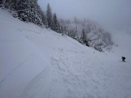
Weak snow at the ground that fell in October and early November has been overloaded by this week’s new snow. Any slope that held snow before last weekend is suspect. The thicker the slab of new snow, the more easily triggered and larger avalanches will be. As Alex and I found in the Bridger Range yesterday, even in parts of the advisory area that have less old snow as you gain elevation there is still plenty of weak snow at the ground to trigger slides (Bridger Range video). An observation of small natural slides in the Hyalite gullies yesterday is a good occasion for a reminder that even small slides need to be taken seriously in very steep terrain (observation).
If you ride on or beneath steep slopes today, expect to trigger avalanches. Avoid the hazard by sticking to lower angled slopes today and avoiding crossing runout zones beneath steeper slopes.
From Bozeman to Island Park and in Cooke City, human triggered avalanches are likely and the avalanche danger is CONSIDERABLE.
If you venture out, please fill an observation form. It does not need to be technical. Did you see any avalanches? How much snow is on the ground? Was the wind moving snow? Simple observations are incredibly valuable. You can also contact us via email (mtavalanche@gmail.com), phone (406-587-6984), or Instagram (#gnfacobs).
Upcoming Avalanche Education and Events
Our education calendar is full of awareness lectures and field courses. Check it out: Events and Education Calendar.
Tuesday, December 12th, 9:00 a.m. to 3:00 p.m., West Yellowstone Motorized Avalanche Fundamentals, Pre-registration and more information HERE.
We offer Avalanche Fundamentals with Field Session courses targeted towards non-motorized users in December and January and one geared towards motorized users in January. Sign up early before they fill up.
Loss in the Outdoors, is a support group for those who have been affected by grief and loss related to outdoor pursuits. Check out the link for more information
Listen to GNFAC Forecaster Dave Zinn on the Hoary Marmot Podcast for some extracurricular avalanche talk (link to episode).