Good morning. This is Dave Zinn with the Gallatin National Forest Avalanche Forecast on Thursday, December 14th at 6:30 a.m. This information is sponsored by Beartooth Powder Guides, BWAGs, and Bozeman Splitfest. This forecast does not apply to operating ski areas.
Bridger Bowl is closed to all uphill traffic. Ski patrol is doing avalanche mitigation in anticipation of opening this Friday, December 15.
Mountain temperatures are inverted this morning, with temperatures in the upper 20s F at mountain tops and teens F at lower elevations. Winds are 5-15 mph, swirling from the southwest to the north. There is no new snow. Today will be sunny with 5-15 mph winds from the west and high temperatures around 30 degrees F.

All Regions
Dangerous avalanche conditions resulting from persistent weak layers require patience from those looking to travel in steep terrain. Stability is slowly improving, with fewer signs of instability warning of the lurking danger, but human-triggered avalanches remain likely.
Recent evidence of the avalanche danger has been plentiful. Yesterday, Ian rode into Tepee Basin and explained that recent avalanches, whumphing collapses, and poor snowpack structure were enough to keep them off steep slopes (video). Skiers in the Bridger Range heard the snowpack collapse on some slopes (observation), and a group south of Livingston, outside the advisory area, heard frequent whumphs as they traveled and observed a couple of recent avalanches (observation). Tuesday, a skier triggered a dangerous slide on Mt. Blackmore in the northern Gallatin Range. Thankfully, quick moves and luck were on his side (observation and video). Ian and Doug assessed the backcountry snowpack at Bridger Bowl and observed a loud collapse in the Fingers Meadow with very unstable snowpit results (photo, snowpit, and video). During an Avalanche Fundamentals Course in the Lionhead Ridge area, our group heard a large whumph (observation).
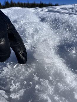
The extended period of high pressure will further weaken the snowpack from the top down and the bottom up. Yesterday, Ian saw “the largest feathers of surface hoar” in his life in Tepee Basin (observation), and riders at Buck Ridge saw blankets of these feathery crystals (observation). Stability will continue to improve as the snowpack finds equilibrium in its current state, but mentally prepare yourself for significant and extended periods of instability when snow returns.
Careful snowpack evaluation, cautious route-finding, and conservative decision-making are essential. The avalanche danger is rated CONSIDERABLE on all slopes.
If you venture out, please fill an observation form. It does not need to be technical. Did you see any avalanches? How much snow is on the ground? Was the wind moving snow? Simple observations are incredibly valuable. You can also contact us via email (mtavalanche@gmail.com), phone (406-587-6984), or Instagram (#gnfacobs).
Upcoming Avalanche Education and Events
Our education calendar is full of awareness lectures and field courses. Check it out: Events and Education Calendar.
TODAY, Thursday, December 14th, 6:30 p.m., Community Partnership Series @ MAP Brewing, featuring Wiley Miller’s “RUN” and Q&A with Miller and GNFAC forecaster Alex Marienthal.
We offer Avalanche Fundamentals with Field Session courses targeted towards non-motorized users in December and January and one geared towards motorized users in January. Sign up early before they fill up.
Loss in the Outdoors is a support group for those affected by loss and grief related to outdoor pursuits. Check out the link for more information.
Listen to GNFAC Forecaster Dave Zinn on the Hoary Marmot Podcast for some extracurricular avalanche talk (link to episode).