Good morning. This is Dave Zinn with the Gallatin National Forest Avalanche Forecast on Tuesday, January 2nd at 6:30 a.m. This information is sponsored by Basecamp Gallatin and Yamaha and Idaho State Snowmobile Association - Avalanche Fund. This forecast does not apply to operating ski areas.
Mountain temperatures are in the teens F this morning with 5-20 mph winds from the west to southwest. There is no new snow. Today, temperatures will be in the 20s to around 30 degrees F, with winds from the west to the south at 5-15 mph. The next chance for snow is Friday into the weekend.

All Regions
The most recent known avalanche in the advisory area occurred eight days ago in the Bridger Range (details), and signs of instability have tapered off. Generally safe avalanche conditions exist, and human-triggered avalanches are unlikely. Small slides in isolated areas and extreme terrain are possible.
As I explained in my video from Beehive Basin yesterday, a slab avalanche requires two characteristics within the snowpack: a relatively weak layer and an overlying slab of more cohesive snow. My ski partner succinctly said, “This snowpack is like my diet over the holidays… it’s all sugar!” As Alex saw yesterday in Cooke City and what we have seen across the advisory area, weeks of mostly sunny weather caused the overlying slab to transform into faceted snow. Lacking the requisite layer of cohesive snow, slab avalanches are unlikely. Alex provided excellent travel advice in his video, recommending that backcountry travelers stay in tune with changes in the snowpack while they travel by poking through it with poles and stepping off sleds or the established skin track to feel for isolated areas with more supportable snow. These or any area with collapsing or shooting cracks are locations where instability may remain.
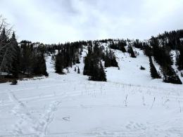
The snowpack has weakened so much that small, loose snow avalanches consisting entirely of weak faceted snow are possible in steep terrain. Yesterday, a skier in Beehive Basin intentionally pushed a pile of these facets downhill in a small slide (photo and details). These small avalanches are dangerous in steep or technical terrain where they can push skiers or riders off cliffs or into obstacles such as rocks or trees.
Low danger does not mean no danger. Utilize standard travel precautions in and around avalanche terrain by carrying rescue gear, traveling one at a time on steep slopes while a partner watches from a safe location, and assessing the snowpack for isolated instability before committing to steep slopes.
The avalanche danger is rated LOW.
If you venture out, please fill an observation form. It does not need to be technical. Did you see any avalanches? How much snow is on the ground? Was the wind moving snow? Simple observations are incredibly valuable. You can also contact us via email (mtavalanche@gmail.com), phone (406-587-6984), or Instagram (#gnfacobs).
Upcoming Avalanche Education and Events
Our education calendar is full of awareness lectures and field courses. Check it out: Events and Education Calendar.
Every weekend in Cooke City: Friday at The Antlers at 7 p.m., Free Avalanche Awareness and Current Conditions talk, and Saturday from 10 a.m.-2 p.m. at Round Lake Warming Hut, Free Rescue Practice.
We offer Avalanche Fundamentals with Field Session courses targeted towards non-motorized travelers in January and one geared towards motorized users. Sign up early before they fill up.
King & Queen 2024, 3 February 2024. Form a team or sign up individually to hike laps on the Bridger Bowl ridge to fundraise for the Friends of the Avalanche Center.
Loss in the Outdoors is a support group for those affected by loss and grief related to outdoor pursuits. Check out the link for more information.
Here’s a quick read, The Invisible Hands of Avalanche Work, an interview with GNFAC forecaster, Doug Chabot.