Good morning. This is Doug Chabot with the Gallatin National Forest Avalanche Forecast on Thursday, January 4th at 6:30 a.m. This information is sponsored by Highline Partners and Alpine Yamaha in Livingston. This forecast does not apply to operating ski areas.
At 5 a.m. mountain temperatures are 15F and wind is west to northwest at 5-15 mph, gusting to 26 mph. Today will be cloudy, temperatures will rise into the mid 20s F and wind will remain moderate out of the west to northwest. Snowfall will start in the predawn hours tomorrow and by 5 a.m. West Yellowstone and Island Park will have 1” of snow with a trace everywhere else. Tomorrow looks to be snowy-ish. Fingers are crossed!

All Regions
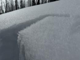
The mountains have 1.5-2.5 feet of snow which has weakened substantially. Grains of snow have metamorphosed into sugary facets which stick together as well as a handful of sand. The snowpack is unsupportable. Ian rode into Taylor Fork yesterday and trenched through the snowpack and sank to the ground as he stepped off his machine (video, Looking Forward). He described the layers in his snowpit to me as, “weak on weak on weak”. Yet weak is not unstable. A slab of cohesive snow is missing from the avalanche recipe and the odds of triggering a slide is minimal.
Areas of concern are slopes or gullies that have wind drifts or a slab of snow overlaying these facets. A whumpf near a steep slope is Mother Nature prompting you to reevaluate your plans. And no matter the avalanche danger, only expose one person at a time in avalanche terrain and carry rescue gear, because sometimes we get surprised and safe travel techniques can save our life.
The snowpack structure is similar throughout our forecast area. Our recent field investigations, which involve navigating downed trees, overheating sleds and avoiding buried obstacles, point to a weak but stable backcountry snowpack. Our videos at Bacon Rind (Dave Zinn Lied), Beehive Basin (The Missing Ingredient), and Cooke City (Avalanches unlikely, but not totally impossible) illustrate similarities between the mountain ranges.
For today, throughout our forecast area, the avalanche danger is rated LOW.
If you venture out, please fill an observation form. It does not need to be technical. Did you see any avalanches? How much snow is on the ground? Was the wind moving snow? Simple observations are incredibly valuable. You can also contact us via email (mtavalanche@gmail.com), phone (406-587-6984), or Instagram (#gnfacobs).
If you get out, please submit an observation. It does not need to be technical. Did you see any avalanches? How much snow is on the ground? Was the wind moving snow? Simple observations are incredibly valuable. You can also contact us by email (mtavalanche@gmail.com), phone (406-587-6984), or Instagram (#gnfacobs).
Here’s a quick read, The Invisible Hands of Avalanche Work, an interview with GNFAC forecaster, Doug Chabot.