Good morning. This is Doug Chabot with the Gallatin National Forest Avalanche Forecast on Wednesday, March 27th at 7:15 a.m. Today’s forecast is sponsored by Bridger Bowl and Advanced Innovation. This forecast does not apply to operating ski areas.
In the last 24 hours 6” has fallen in the Bridger Range, in Hyalite and around Big Sky. All other areas received an inch of snow. Wind is blowing W-NW at 10-25 mph with temperatures in the mid teens F. Skies will turn from partly cloudy during the day to cloudy by this evening. Temperatures are forecasted to reach the upper 30s F. The mountains around Island Park, West Yellowstone and Cooke City will get 1-3” of snow by morning with more tomorrow.

In the mountains around Bozeman and Big Sky, 3-4” fell yesterday with another 2-3” last night. Even 15 mph wind was strong enough to create 6-8” wind slabs that avalanched naturally in the backcountry (Frazier Basin observation). Last night’s snow and similar wind will create a few natural slides and conditions for people to easily trigger wind drifts, much like Alex found on Sunday on Buck Ridge (video)
A secondary, but more consequential concern, are avalanches that break on weak snow found in the bottom third of the snowpack. These avalanches are deep and can propagate wide, but they are not easy to trigger. Possible ways are a cornice breaking or avalanche tumbling down the hill, or a person collapsing the weak layer from a thin area of the slope. Snowfall since Saturday, wind-loading in starting zones, and underlying weak snow near the ground leads me to give conservative travel advice. If you get into avalanche terrain do so incrementally, and find slopes that were not affected by the wind.
The avalanche danger is CONSIDERABLE on all wind-loaded terrain and MODERATE on all others.

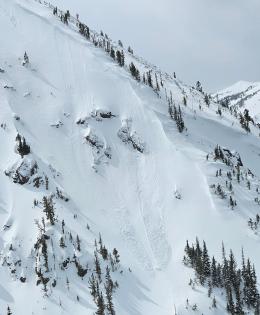
The avalanche potential in the southern mountains is two fold: shallow wind slabs which are easy to see, feel and mitigate, and a deeply buried weak layer which is difficult to trigger. Around Cooke City skiers saw and triggered a few wind slab avalanches (observation 1, 2, and 3). Without fresh snow these will be more difficult to trigger today. Near the ground is weak snow that has been avalanching all winter, sometimes with just a few inches of snow or days after a storm. It’s been over a week since we had one reported. A trigger like a cornice breaking, or a person hitting a shallow part of a slope, could trigger a large avalanche. Even though the odds are going down it is not out of the question.
Dave and Ian were in Taylor Fork yesterday and found a thin layer of facets under the new snow and/or melt-freeze crust from last week. This layer easily broke in their stability test. Ian pointed out in his video, “Snowpits can shine to give us feedback” on the upper layers. As we travel into avalanche terrain, it’s not just the layers near the ground we are concerned with. Stability tests are pointing out weakness near the surface, a potential problem with more snowfall.
The avalanche danger is rated MODERATE on all slopes.
If you get out please submit an observation. It does not need to be technical. Did you see any avalanches? How much snow is on the ground? Was the wind moving snow? Simple observations are incredibly valuable. You can also contact us by email (mtavalanche@gmail.com), phone (406-587-6984), or Instagram (#gnfacobs).
Upcoming Avalanche Education and Events
Our education calendar is full of awareness lectures and field courses. Check it out: Events and Education Calendar.
Loss in the Outdoors is a support group for those affected by loss and grief related to outdoor pursuits. Check out the link for more information.
If you have a few minutes, take a survey on how you interpreting avalanche forecast information in hopes of improving avalanche forecasting methods.