Good morning. This is Ian Hoyer with the Gallatin National Forest Avalanche Forecast on Saturday, April 6th, at 7:00 a.m. Today’s forecast is sponsored by Montana State Parks and Klim. This forecast does not apply to operating ski areas.
Temperatures fell below freezing last night for the first time in several days. A dusting to an inch of new snow fell around Bozeman, Big Sky, and Cooke City, with 2-3” around West Yellowstone and Island Park. After blowing hard overnight during the frontal passage, winds are now 5-15 mph out of the west. Winds will pick back up this afternoon. High temperatures will be in the 20s and low 30s F. Snowfall will start this morning in northern areas and spread south during the day. Expect 3-6” to fall by tomorrow morning.

All Regions
There is a good bit of uncertainty today in the avalanche conditions you might encounter, with a mixed bag of wet and dry avalanches possible.
In most places, wet snow concerns will be minimal because yesterday’s snow surface will either have a hard, thick, refrozen crust, or the snowpack stayed dry through the warmup (on high elevation shady slopes). But, it hasn’t been that cold for that long, so there will still be plenty of places with wet snow in the middle of the snowpack. If the crust is thin, or it gets loaded rapidly by new snow today, you might be able to trigger avalanches in the wet snow beneath. Be wary if you break through a surface crust into wet snow below.
I expect the little bit of new snow to be generally well bonded to the old snow surface and in many spots the new snow isn’t deep enough to cause a consequential slide. Be on the lookout for places where one or both of those things isn’t true. Pay close attention to how deep drifts are and how well they are bonded. Shooting cracks are a clear sign you’ve found an unstable drift. Stay alert as there is the potential for some short bursts of high intensity snowfall today that could change conditions rapidly.
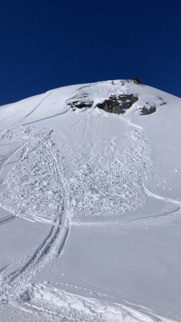
New snow also increases the chances of triggering a slide on buried weak layers, particularly those in the upper 1-2 ft of the snowpack (Lionhead video, Fin photo). Take a few minutes to dig down and test these weak layers before committing to a steep slope. The weak snow at the ground is hard to test and triggering an avalanche down there is unlikely, but still a possibility that should not be entirely forgotten.
The avalanche danger is MODERATE today.
If you get out please submit an observation. It does not need to be technical. Did you see any avalanches? How much snow is on the ground? Was the wind moving snow? Simple observations are incredibly valuable. You can also contact us by email (mtavalanche@gmail.com), phone (406-587-6984), or Instagram (#gnfacobs).
Upcoming Avalanche Education and Events
Hyalite Road Closure: Hyalite road is closed to ALL MOTORIZED VEHICLES until the morning of May 16. This is a regular annual road closure to reduce road damage during the spring thaw. Bicycle and foot traffic are allowed. Contact the Bozeman FS Ranger District for more info.
Events and Education Calendar.
Loss in the Outdoors is a support group for those affected by loss and grief related to outdoor pursuits. Check out the link for more information.
The total number of avalanche deaths in the US stands at 13. On March 29, a snowboarder was killed on Mt. St. Helens when a cornice he was standing on broke and triggered the slope below.