Good morning. This is Dave Zinn with avalanche and weather information from the Gallatin National Forest Avalanche Center on Friday, December 1st, at 7:00 a.m. This information is sponsored by Idaho State Snowmobile Association - Avalanche Fund and the Avalanche Alliance and will be updated as conditions change.
Finally, it is snowing. Mountain temperatures are in the single digits to 20 degrees F with 5-15 mph winds from the west. The mountains around Bozeman, Big Sky and West Yellowstone have received 1-2” of snow as of Friday morning, with no measurable snow in Island Park and Cooke City yet.
This weekend, high temperatures will begin in the teens to mid-20s F and slowly creep up to the 20s to high 30s F by Sunday. Winds will peak Saturday into Saturday night, blowing from the west to southwest at 20-35 mph. By the end of the weekend, the mountain around Bozeman and Big Sky will get around 6” of snow with 10-12” in West Yellowstone and Island Park and 10-20” in Cooke City.

Our weeklong dry spell is over, and it is starting to snow. What was dry ground at lower elevations transitions to 1-2+ feet of snow as the elevation increases. The avalanche danger will rise through the weekend as snow falls. Higher precipitation amounts in Cooke City, West Yellowstone and Island Park will spike the avalanche danger upwards. Lower snow totals farther north in the advisory area will increase the danger but not as significantly.
The snow that was on the ground before this weekend is generally weak. Alex was in the Northern Madison Range yesterday (Thursday) digging into about a foot of sugary, faceted snow (video), mirroring what Ian found on Sawtelle Peak two weeks ago (observation) and what skiers recently observed near Cooke City (Observation 1, 2). Assume that snow on the ground before this weekend is a persistent weak layer that will avalanche when loaded and will stabilize slowly.
In addition to loading a thin snowpack largely consisting of weak, sugary facets for the first time this season, temperatures will warm as the weekend progresses, trapping light fluffy powder below heavier snow. Strong winds on Saturday will load new snow onto slopes in thick drifts.
Snowfall on weak layers, the “upside down snowstorm” (heavier snow over lighter snow) and strong winds will all create instability. Seek out lower-angle terrain in areas where new snow adds up to more than a few inches because our uncertainty levels are high as we get to know this season’s snowpack. Signs such as recent avalanches, collapses or whumphing and shooting cracks show you that the snowpack is ready to slide. The subsequent avalanches will not care that you are excited that it’s finally snowing.
If you venture out, please fill an observation form. It does not need to be technical. Did you see any avalanches? How much snow is on the ground? Was the wind moving snow? Simple observations are incredibly valuable. You can also contact us via email (mtavalanche@gmail.com), phone (406-587-6984), or Instagram (#gnfacobs).
What was dry ground at lower elevations transitions to 1-2+ feet of snow as the elevation increases. The avalanche danger will rise through the weekend as around a foot of snow falls. Seek out lower-angle terrain where new snow adds up to more than a few inches. On November 15, Ian saw that the 20” of snow at our Sawtelle Weather Station had weakened into sugary facets. It has not improved since then (observation and photos). Snowfall on weak layers, warming temperatures through the weekend and strong winds will all increase the danger. Signs such as recent avalanches, collapses or whumphing and shooting cracks show you that the snowpack is ready to slide.
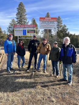
Yesterday (Thursday), I met up with the Fugawee Snowmobile Club, Idaho Parks and Recreation and Klim as the group installed new beacon checkers at the trailheads in Island Park. It was a beautiful day and we appreciate everyone’s effort to make this happen (photos 1, 2, 3)!
Upcoming Avalanche Education and Events
Our education calendar is full of awareness lectures and field courses. Check it out: Events and Education Calendar.
Monday, December 4th, 6:30 p.m., FREE Avalanche Awareness at MAP Brewing
Tuesday, December 5th, 6:00 p.m., Free Avalanche Awareness + Beacon Demo Clyde Park Community Hall, hosted by the Big Sky SnowRiders
Tuesday, December 9th, 9:00 a.m. to 3:00 p.m., West Yellowstone Motorized Avalanche Fundamentals, Pre-registration and more information HERE.
We offer Avalanche Fundamentals with Field Session courses targeted towards non-motorized users in December and January and one geared towards motorized users in January. Sign up early before they fill up.
Loss in the Outdoors, is a support group for those who have been affected by grief and loss related to outdoor pursuits. Check out the link for more information.
We travel with a lot of electronics that could interfere with our avalanche transceiver, both as a victim and as a rescuer. Check out our article on Electronic Warfare to learn what to do.