Good morning. This is Doug Chabot with the Gallatin National Forest Avalanche Forecast on Tuesday, December 12th at 6:45 a.m. This information is sponsored by Gallatin Valley Snowmobile Association and Bridger Bowl. This forecast does not apply to operating ski areas.
Bridger Bowl is closed through Thursday. Uphill travel is permitted until 5pm today, then uphill travel will be prohibited until further notice. Backcountry conditions exist with no avalanche mitigation or ski patrol services. Call 911 for rescue.
At 5 a.m. the mountains around Bozeman received 2” of snow. Wind is out of the west at 5-10 mph with gusts of 20 mph in the Bridger Range. Temperatures are in the mid teens F and will rise to the upper 20s F today under partly cloudy skies. Wind will remain light from the west and no new snow is expected for the rest of the week.

All Regions
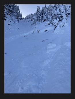
Every day over the last 5 days, somewhere in our forecast area the snowpack has either avalanched or collapsed with a “whumpf”. Our snowpack depth may vary, but its weak and unstable structure is ubiquitous. Right now, avalanches in one mountain range mean they can occur in others. In all areas, the lower part of the snowpack consists of sugary facets that are struggling to support the snow above it. Yesterday, Dave and his partner rode into Taylor Fork and found 2 avalanches, had a large whumpf as he approached his pit site, and got a very poor result in his stability test (video). Any one of these is a clear warning to stay out of avalanche terrain (slopes steeper than 30०). Yesterday, skiers on Mt. Blackmore in the northern Gallatin Range saw an avalanche, heard whumpfs and also had poor test scores, another trifecta of instability (photo). Further away in Cooke City, skiers had multiple whumpfs as they toured (observation). A whumpf is the sound of the snowpack collapsing from your weight; it is an avalanche on the flats. If the collapsing layer propagates onto a steep hill, it will avalanche, which is what snowmobilers experienced in Teepee Basin in the southern Madison Range on Saturday (photo).
The snowpack is unstable everywhere in our forecast area. Triggering avalanches is likely and we advise staying out of avalanche terrain. Look at our Weather and Avalanche Log to understand the breadth of the instability, and read the Observations for more details.
Throughout our forecast area, the avalanche danger is rated CONSIDERABLE on all slopes.
If you venture out, please fill an observation form. It does not need to be technical. Did you see any avalanches? How much snow is on the ground? Was the wind moving snow? Simple observations are incredibly valuable. You can also contact us via email (mtavalanche@gmail.com), phone (406-587-6984), or Instagram (#gnfacobs).
Upcoming Avalanche Education and Events
Our education calendar is full of awareness lectures and field courses. Check it out: Events and Education Calendar.
Thursday, December 14th, 6:30 p.m., Community Partnership Series @ MAP Brewing, featuring “RUN” with Wiley Miller, and Q&A with GNFAC forecaster Alex Marienthal.
We offer Avalanche Fundamentals with Field Session courses targeted towards non-motorized users in December and January and one geared towards motorized users in January. Sign up early before they fill up.
Loss in the Outdoors, is a support group for those who have been affected by grief and loss related to outdoor pursuits. Check out the link for more information.