Good morning. This is Ian Hoyer with the Gallatin National Forest Avalanche Forecast on Saturday, December 23rd at 7:00 a.m. This information is sponsored by Highline Partners and Gallatin County Sheriff Search and Rescue. This forecast does not apply to operating ski areas.
As of 6 a.m. 5” of new snow have fallen in Island Park, 2-4” around Big Sky and West Yellowstone and a trace to an inch near Bozeman and Cooke City. Winds are 10-20 mph out of the southwest to west with 30-50 mph gusts. Temperatures are in the 20s F this morning and will stay steady or drop throughout the day. Snowfall will continue this morning with another 2-4” expected, favoring the Big Sky, West Yellowstone and Island Park areas. Snowfall will taper off this afternoon.

New snow falling on a weak snowpack has pushed it to its breaking point. A few inches of new snow may not seem like a big deal, but with such a weak snowpack it is. Human triggered avalanches are likely.
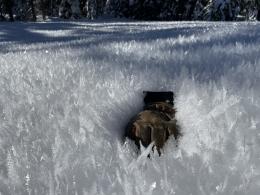
Avalanche can be triggered on weak layers throughout the thin snowpack. The snow that fell during October and November became extremely weak and faceted before being capped by a slab of snow that fell in early December. Over the last couple weeks, that more recent snow has also weakened and faceted and weak feathers of surface hoar have grown on top of it all across the region (photo). With strong winds building deeper drifts it doesn’t really matter where the slide breaks, it will be deep enough to be dangerous.
Today is a day to avoid steep slopes and give them a wide berth as you pass beneath them, because triggering a slide from below is a real concern. Natural avalanches may also break by themselves, without any additional loading from a person.
The avalanche danger is CONSIDERABLE in the mountains around Island Park, West Yellowstone, and Big Sky.

The mountains near Bozeman and Cooke City have the same weak snowpack, but less new snow. A trace to an inch overnight and an inch or two during the day isn’t quite enough to make a change in the danger. Stay heads up for changing conditions and think carefully before entering avalanche terrain. Triggering a dangerous avalanche is still a real possibility. Do not underestimate how weak the snowpack is (Cooke CIty video). Choosing to avoid steep slopes today is a reasonable decision.
If you do plan to enter avalanche terrain, watch for signs of instability (cracking, collapsing, or recent avalanches) and if you see them, back off. Dig a snowpit to look for less obvious signs of instability. And carefully consider the consequences of triggering a slide on any given slope.
The avalanche danger is MODERATE in the Bridger Range, northern Gallatin Range, and mountains around Cooke City.
The only thing keeping the danger from spiking in these areas is that there is less new snow - if it snows more than expected, the avalanche danger will quickly rise to CONSIDERABLE.
If you venture out, please fill an observation form. It does not need to be technical. Did you see any avalanches? How much snow is on the ground? Was the wind moving snow? Simple observations are incredibly valuable. You can also contact us via email (mtavalanche@gmail.com), phone (406-587-6984), or Instagram (#gnfacobs).
Upcoming Avalanche Education and Events
Our education calendar is full of awareness lectures and field courses. Check it out: Events and Education Calendar.
We offer Avalanche Fundamentals with Field Session courses targeted towards non-motorized travelers in January and one geared towards motorized users. Sign up early before they fill up.
Loss in the Outdoors is a support group for those affected by loss and grief related to outdoor pursuits. Check out the link for more information.
Feathery crystals of surface hoar blanket our advisory area. Bruce Jamieson and Simon Horton made a 3-part video series on how it forms and why it’s a problem.