Good morning. This is Dave Zinn with the Gallatin National Forest Avalanche Forecast on Tuesday, January 30th at 6:45 a.m. Today’s forecast is sponsored by the Knoff Group Real Estate, Werner Wealth Management (Advisors with DA Davidson) and Ride Rasmussen Style. This forecast does not apply to operating ski areas.
Low temperatures for the night were above freezing across the advisory area other than Cooke City, where the Fisher Creek SNOTEL is at 23 degrees F. Winds are 5-15 mph from the west to the south. Today, temperatures will climb into the 40s F with 50 F in the Bridger Range and sunny skies.

We have two concerns in the mountains around Bozeman and Big Sky. Wet snow avalanches as the day warms and dry slab avalanches breaking on persistent weak layers.
Thin crusts at the snow surface will disappear quickly this morning, and the wet snow danger will increase. Yesterday, the Bridger Bowl Snow Safety team reported their first natural avalanche at 11 a.m. Climbers in Hyalite Canyon reported icefall, wet slides coming out of the gullies, and small wet avalanches in steep rocky terrain (observation, observation). These will increase in volume and likelihood today. Destructive wet slab avalanches are possible. Be clear of slopes and runout zones before the snow becomes unsupportable and slushy.
The danger from dry slab avalanches failing on persistent weak layers continues. Two days ago, a group on Bridger Peak knocked a small chunk of cornice onto the slope, triggering an avalanche that propagated out and ran far downslope (video and details). Careful snowpack assessment and route-finding are essential for safer travel in and around avalanche terrain.
The danger is CONSIDERABLE for dry snow avalanches in the Northern Madison and Northern Gallatin Ranges, where triggering an avalanche is likely, and MODERATE for dry snow avalanches in the Bridger Range, where human-triggered avalanches are possible. As the day warms, the danger will rise to HIGH for wet snow avalanches.

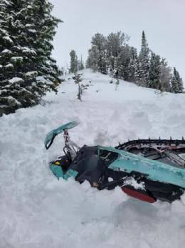
Yesterday in Cooke City, a snowmobiler triggered an avalanche, was caught, pulled his airbag, and was buried with his head out of the snow under his sled (photo and details). The avalanche forecast repeating, “danger, danger, danger,” can begin to lose its impact, but the fact remains dangerous avalanche conditions exist near West Yellowstone, Island Park, and Cooke City due to the weakest snowpack in recent memory and now, above-freezing temperatures (read Chabot’s message).
The danger of wet snow avalanches will increase throughout the day. Avoid steep slopes when crusts break down and the surface snow gets wet. Human-triggered and natural avalanches will become likely. A moist snow surface and cinnamon roll-like pinwheels rolling downhill are your first indicators to get clear of sun-exposed slopes.
Persistent weak layers buried 1-3 feet deep are resulting in daily avalanche activity (log). The mountains around Cooke City continue to produce slides and signs of instability (Doug’s Cooke City Observations and video, Woody Ridge Natural, Republic Creek recent activity). Similar conditions exist in Island Park, where I rode in a cloud and had trouble spotting many slides yesterday (observations and video). At Lionhead, a snowmobiler cannonballed onto a small test slope and triggered a miniature avalanche, telling us that larger ones remain likely (video and details). Backcountry travelers continue to report collapsing and unstable test results (observation 1 and 2). Accurate identification of avalanche terrain (video, video), conservative route selection, minimizing exposure to steep slopes, and safe travel protocols are critical.
The danger of wet and dry snow avalanches is CONSIDERABLE.
If you venture out, please fill an observation form. It does not need to be technical. Did you see any avalanches? How much snow is on the ground? Was the wind moving snow? Simple observations are incredibly valuable. You can also contact us via email (mtavalanche@gmail.com), phone (406-587-6984), or Instagram (#gnfacobs).
Upcoming Avalanche Education and Events
Our education calendar is full of awareness lectures and field courses. Check it out: Events and Education Calendar.
Every weekend in Cooke City: Friday at The Antlers at 7 p.m., Free Avalanche Awareness and Current Conditions talk, and Saturday from 10 a.m.-2 p.m. at Round Lake Warming Hut, Free Rescue Practice.
Tuesday, 30 January, 6:30 p.m., FREE 1-Hour Avalanche Awareness at the Beall Center in Bozeman.
9-10 February. Companion Rescue Course. More information and registration HERE.
9-10 February. Dillon Montana Avalanche Fundamentals. More information and registration for the MOTORIZED SECTION and NON-MOTORIZED SECTION
King & Queen 2024, 3 February 2024. Form a team or sign up individually to hike laps on the Bridger Bowl ridge to fundraise for the Friends of the Avalanche Center.
Loss in the Outdoors is a support group for those affected by loss and grief related to outdoor pursuits. Check out the link for more information.
KING AND QUEEN OF THE RIDGE, FEBRUARY 3rd
Do you like to hike? Do you like to ski? Then the King & Queen of the Ridge is for you. Hike, ski and raise money for the Friends of the Avalanche Center in their 2nd biggest fundraiser of the year. Join the effort to promote and support avalanche safety and awareness! Fundraising prizes for the top 5 individuals who raise over $500. No racing is necessary to compete for the fundraising prizes. Info is HERE. Race participants for the February 4th event must register separately with Bridger Bowl HERE.
This year's snowpack is not to be trifled with. Read Doug’s important thoughts about the unusually unstable snowpack on this recent Instagram post.