Good morning. This is Doug Chabot with the Gallatin National Forest Avalanche Forecast on Wednesday, January 31st at 7:00 a.m. Today’s forecast is sponsored by the Yellowstone Club Community Foundation and Basecamp Gallatin and Yamaha. This forecast does not apply to operating ski areas.
Under clear skies, last night’s low temperatures remained above freezing in the Bridger Range, upper elevations of Hyalite and Big Sky. Wind is W-SW at 10-20 mph with gusts of 43 mph in Island Park. Today will be breezy, sunny and temperatures reaching the mid-40s F in the north and high 30s F in the southern mountains.

The mountains surrounding Bozeman and Big Sky will have wet avalanches on sunny slopes. Today is windier than yesterday which could inhibit melting. I expect pinwheels and wet loose avalanches on all sunny slopes. If melting snow percolates water to the faceted snow 1.5-2 feet under the surface we would get large wet avalanches. Less wind or having the temperatures climb higher than predicted could quickly tip the balance toward wet instability. Wetting the top few inches of the snowpack is a sign the danger is rising. The wet snow avalanche danger could reach HIGH today.
Staying on high elevation, shady slopes will free you from the wet avalanche danger, but you’ll still have to contend with the dry snow instability: weak, sugary facets capped with a 1.5-2 foot slab of snow. This interface breaks in our stability tests and avalanches are possible to trigger (Bridger Peak avalanche). Ian was in Frazier Basin yesterday and had to deal with the bi-polar nature of the snowpack: both wet and dry instability (video). For today, the dry snow avalanche danger is MODERATE.
If you go in the backcountry you will contend with both wet and dry avalanche danger. So what should you do? Have you tried mountain biking in Copper City? Joking aside, conditions for skiing and snowmobiling are marginal and the avalanche danger is real so stay away from wet, sunny slopes and be careful on shady, dry aspects.

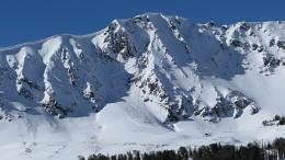
The mountains around West Yellowstone, Island Park and Cooke City will get pinwheels of snow from the sunny, warm weather (photo), but these wet instabilities will be confined to the surface and not pose a significant danger. A person could trigger wet loose slides, but this hazard can be managed by avoiding slopes that get gloppy.
The dry snow avalanche danger is the beast we are worried about. On Sunday, two natural avalanches on Henderson Ridge in Cooke City broke free (video), on Monday a snowmobiler was partially buried in a small slide (video) at Round Lake, and ice climbers triggered a slide 150 feet away as they hiked in toward Pilot Peak (observation). In Island Park the clouds finally lifted and riders saw many slides from the previous week (pictures).
The southern mountains share a similar snowpack. Our videos show the same thing over and over (Dave’s video). New snow and wind blown snow created 2+ feet thick slabs of snow that are sitting on a weak layer of sugary facets. All the avalanche activity is happening at this interface and triggering a slide is likely. Given the constant drumbeat of avalanches and collapsing, avoiding slopes steeper than 30 degrees is a safe tactic. The dry snow avalanche danger is rated CONSIDERABLE on all slopes.
If you venture out, please fill an observation form. It does not need to be technical. Did you see any avalanches? How much snow is on the ground? Was the wind moving snow? Simple observations are incredibly valuable. You can also contact us via email (mtavalanche@gmail.com), phone (406-587-6984), or Instagram (#gnfacobs).
Upcoming Avalanche Education and Events
Our education calendar is full of awareness lectures and field courses. Check it out: Events and Education Calendar.
Every weekend in Cooke City: Friday at The Antlers at 7 p.m., Free Avalanche Awareness and Current Conditions talk, and Saturday from 10 a.m.-2 p.m. at Round Lake Warming Hut, Free Rescue Practice.
Tuesday, 30 January, 6:30 p.m., FREE 1-Hour Avalanche Awareness at the Beall Center in Bozeman.
9-10 February. Companion Rescue Course. More information and registration HERE.
9-10 February. Dillon Montana Avalanche Fundamentals. More information and registration for the MOTORIZED SECTION and NON-MOTORIZED SECTION
King & Queen 2024, 3 February 2024. Form a team or sign up individually to hike laps on the Bridger Bowl ridge to fundraise for the Friends of the Avalanche Center.
Loss in the Outdoors is a support group for those affected by loss and grief related to outdoor pursuits. Check out the link for more information.
KING AND QUEEN OF THE RIDGE, FEBRUARY 3rd
Do you like to hike? Do you like to ski? Then the King & Queen of the Ridge is for you. Hike, ski and raise money for the Friends of the Avalanche Center in their 2nd biggest fundraiser of the year. Join the effort to promote and support avalanche safety and awareness! Fundraising prizes for the top 5 individuals who raise over $500. No racing is necessary to compete for the fundraising prizes. Info is HERE. Race participants for the February 4th event must register separately with Bridger Bowl HERE.
This year's snowpack is not to be trifled with. Read Doug’s important thoughts about the unusually unstable snowpack on this recent Instagram post.