Good morning. This is Doug Chabot with the Gallatin National Forest Avalanche Forecast on Thursday, February 1st at 6:45 a.m. Today’s forecast is sponsored by the Montana State Parks and Alpine Yamaha in Livingston. This forecast does not apply to operating ski areas.
Clear skies and warm weather will continue today. Last night did not freeze in the Bridger Range, but Hyalite and Big Sky did, barely. Wind out of the west to southwest is averaging 15-25 mph with gusts of 48 mph. Daytime temperatures will reach into the mid to upper 40s F in the north and mid to upper 30s in the south. No new snow is expected overnight, but this weekend Winter will return after her quick beach vacation to Cabo.

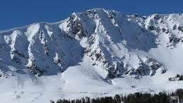
Wet avalanches are our primary concern today. This is the 4th day in a row with no freeze or a light freeze in the mountains around Bozeman and Big Sky. Ian rode into Buck Ridge yesterday and saw wet slab avalanches, some big, on Cedar Mountain, and lots of wet loose rollerballs (observations and photos, video). His stability test scores were shockingly low and he got a large collapse when he stepped out of his snowpit. The thin, exceptionally weak snowpack, is susceptible to wet slab avalanches on sunny slopes. We don’t have a lot of experience with wet slides on a thin snowpack this early in the winter, but we recognize it is dangerous. Thus, the wet snow avalanche danger could reach HIGH today.
If you are hunting for dry snow on upper elevation shady slopes, you’ll have to pass through zones that are wet. If you persevere, you will need to contend with a snowpack that has a poor structure and remains unstable on some slopes. Weak, sugary snow the bottom half of the snowpack is capped by a 1.5 to 2 foot thick slab of snow. Ian was in the Fairy Lake area in the Bridger Range on Tuesday and navigated the wet and dry snowpack. He found it possible to trigger an avalanche at the interface between the slab and sugary facets (video). This story is the same throughout our northern ranges and the dry snow avalanche danger is rated MODERATE.

Around West Yellowstone, Island Park and Cooke City the surface snow got moist and a few wet avalanches from Tuesday were noted in Cooke City (observation). A dry snow avalanche on Daisy Pass Tuesday afternoon was likely triggered at the interface between a dense wind slab and loose, sugary facets underneath (photos). This recipe of weak, unstable facets avalanching both naturally and with human triggers is everywhere in the southern mountains. I spent Sunday through Tuesday in Cooke City and found instability and an identical snow structure at the avalanche near Round Lake that partially buried a rider, at a large avalanche on Henderson Mountain, the 2 smaller natural slides on Henderson Ridge, and up Fisher Creek. Dave found the same thing in Island Park (video), and we know the mountains in between are similar. Triggering avalanches is likely, even from hundreds of feet away. On Monday, ice climbers hiking near Pilot Peak had a whumpf which triggered a large slide 150 feet distant (observation).
The snowpack remains unstable long after receiving a load of new snow. Recent avalanche activity, collapsing, and wet snow on sunny slopes are evidence to approach avalanche terrain very carefully. For today, the avalanche danger is CONSIDERABLE on all slopes.
If you venture out, please fill an observation form. It does not need to be technical. Did you see any avalanches? How much snow is on the ground? Was the wind moving snow? Simple observations are incredibly valuable. You can also contact us via email (mtavalanche@gmail.com), phone (406-587-6984), or Instagram (#gnfacobs).
POSTPONED: King and Queen of the Ridge, February 3rd
Bridger Bowl’s community event series events this weekend are postponed, including King & Queen - stay tuned, details TDB.
Upcoming Avalanche Education and Events
Our education calendar is full of awareness lectures and field courses. Check it out: Events and Education Calendar.
Every weekend in Cooke City: Friday at The Antlers at 7 p.m., Free Avalanche Awareness and Current Conditions talk, and Saturday from 10 a.m.-2 p.m. at Round Lake Warming Hut, Free Rescue Practice.
POSTPONED: King and Queen of the Ridge, February 3rd. Bridger Bowl’s community event series events this weekend are postponed, including King & Queen - stay tuned, details TDB.
This year's snowpack is not to be trifled with. Read Doug’s important thoughts about the unusually unstable snowpack on this recent Instagram post.