Good morning. This is Dave Zinn with the Gallatin National Forest Avalanche Forecast on Wednesday, March 13th at 7:00 a.m. Today’s forecast is sponsored by Klim and the Avalanche Alliance. This forecast does not apply to operating ski areas.
This morning, temperatures are in the teens to mid-20s F, with 5-15 mph winds from the west to the north. In the last 24 hours, the mountains in Island Park received 8” of new snow, with 4-6” near West Yellowstone, Big Sky, and Cooke City and 3” near Bozeman. Today, temperatures will be in the 20s to low-30s F, with 5-15 mph winds from the northwest. The mountains will receive an additional 1-3” of snow by tomorrow morning.

Human-triggered avalanches are likely in the mountains south of Bozeman through Island Park and Cooke City. Forty-eight-hour snow totals range from 3-6” with 0.3-0.6” of snow water equivalent near Bozeman, Big Sky, West Yellowstone, and Cooke City to one foot with 1.2” of snow water equivalent in the Centennial Mountains in Island Park.
Persistent weak layers deep in the snowpack have resulted in spectacularly large and dangerous avalanches within the last week. Similar slides are possible today. Highlights from the long list available on our avalanche activity log include, in Cooke City, huge slides on Sheep Mountain (photos), Miller Mountain (video, photo), Scotch Bonnet (details, details), and Henderson Mountain (video and details). Near Bozeman and Big Sky, a very large avalanche failed naturally on the north side of Mount Blackmore, snapping off mature trees (overview video and photos). Three avalanches in Beehive Basin broke 3-5 feet deep (video, details, photos), and a rider remotely triggered a large avalanche at Buck Ridge last week (photo).
Avalanches do not have to break many feet deep to be dangerous. Relatively small avalanches can cause trauma or bury skiers or riders. Slabs of new and wind-drifted snow on steep slopes are likely to avalanche under the weight of a skier or rider. The depth will vary from 6 to 24” depending on the amount of new snow in the area. Doug and I noted what we expect to be short-lived instability below the recent snow in Island Park yesterday (video).
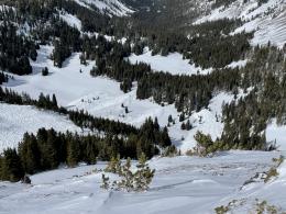
Avoid steep avalanche paths. Select simple, lower-angle terrain without the added risk of terrain traps and follow safe travel protocols. Watch our videos from West Yellowstone and Big Sky discussing terrain selection (video, video).
The avalanche danger is CONSIDERABLE.

While the snowpack's foundation remains weak, instability is most likely within the new and wind-drifted snow in the Bridger Range. Recent avalanches on Saddle Peak (details and photos) and Naya Nuki (photos) indicate the types of slides backcountry travelers may encounter today. Relatively small avalanches can push skiers and riders into dangerous obstacles like rocks, trees, and cliffs and can bury us, especially if gullies or trees are present.
Avoid avalanche terrain on slopes where you note signs of instability, including unstable test results, shooting cracks, or signs of recent wind-loading. Choose to recreate on simple, low-consequence terrain and slopes sheltered from the wind. Rescue gear and safe travel protocols with a partner minimize the consequences of mistakes.
Human-triggered avalanches are possible, and the avalanche danger is rated MODERATE.
If you venture out, please fill an observation form. It does not need to be technical. Did you see any avalanches? How much snow is on the ground? Was the wind moving snow? Simple observations are incredibly valuable. You can also contact us via email (mtavalanche@gmail.com), phone (406-587-6984), or Instagram (#gnfacobs).
Upcoming Avalanche Education and Events
Our education calendar is full of awareness lectures and field courses. Check it out: Events and Education Calendar.
Next weekend in Cooke City: Friday at The Antlers at 7 p.m., Free Avalanche Awareness and Current Conditions talk, and Saturday from 10 a.m.-2 p.m. at Round Lake Warming Hut, Free Rescue Practice.
Loss in the Outdoors is a support group for those affected by loss and grief related to outdoor pursuits. Check out the link for more information.
We are deeply saddened to share the loss of two avalanche professionals from the Pacific Northwest last week. Nick Burks, who was a forecaster for the Wallowa Avalanche Center died in an avalanche accident while skiing with a friend on Wednesday, March 6 (details). Matt Primomo, who was an avalanche forecaster for the Northwest Avalanche Center, died in a non-avalanche related accident on Thursday, March 7. Our thoughts are with our colleagues, their friends, families, and the communities which these people were a major part of.