Good morning. This is Dave Zinn with the Gallatin National Forest Avalanche Forecast on Tuesday, April 2nd, at 7:00 a.m. Today’s forecast is sponsored by Basecamp Gallatin and Yamaha and the Idaho State Snowmobile Association - Avalanche Fund. This forecast does not apply to operating ski areas.
Mountain temperatures are in the 20s to low 30s F this morning, with 5-20 mph winds from the west to northwest. There is no new snow. Today, temperatures will climb into the 40s and 50s F under sunny skies. Winds will be 5-15 mph from the southwest to northwest. Cooler temperatures and snow will return late in the week.

All Regions
Conditions change rapidly in the spring, and travel plans should reflect these daily fluctuations. While not equal in likelihood, wet snow avalanches, dry slab avalanches failing in the upper snowpack and deep slab avalanches failing on basal weak layers are all potential problems today.
Natural and human-triggered wet snow slides will become likely as the spring sun blazes and temperatures rise into the 40s and 50s F. These will generally present as wet loose avalanches that start at a point and fan out as they entrain snow. The weight of these slides pack a serious punch. Yesterday, the Big Sky and Bridger Bowl Ski Patrols observed limited wet snow instability when small natural avalanches occurred in closed terrain. We will likely see more today. Wet snow instability is rising as the surface snow gets wet (duh!) and pinwheels of snow start rolling downhill like giant cinnamon rolls. Quickly move to cooler aspects, lower-angle slopes or head home as instability increases, and preemptively ensure a safe exit plan.
Avalanches breaking 1-2 feet deep below recent and wind-drifted snow are possible. Riding in Island Park yesterday, we saw five avalanches that likely failed at the end of last week (video). On Sunday, a “pow surfer” (snowboarder without bindings) was buried to his chest by an avalanche that broke below the recent storm snow at Lionhead Ridge (photo), and a snowboarder (with bindings) triggered a collapse that shot cracks 25 feet near the Sphinx (observation). Continued instability is most likely on slopes where newer weak layers exist immediately below recent snow, as Alex saw in the Taylor Fork (video) and I found in one of our Island Park pits (observation). Test the upper three feet of the snowpack for instability and back off if you find it.
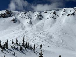
While less likely, avalanches last week on Flanders Mountain (photos, video) and Mt. Blackmore (photos) in the northern Gallatin Range that broke 2-6 feet deep show the continued potential for deep slab releases. A wet snow or wind-slab avalanche, cornice fall, or an unlucky backcountry traveler crossing just the wrong spot could trigger a large slide. Conservative terrain choice and safe travel practices are the only effective management strategies. Avoid large, heavily wind-loaded slopes often overhung by enormous cornices.
The avalanche danger is MODERATE this morning and will rise to CONSIDERABLE as wet snow avalanches become likely.
If you get out please submit an observation. It does not need to be technical. Did you see any avalanches? How much snow is on the ground? Was the wind moving snow? Simple observations are incredibly valuable. You can also contact us by email (mtavalanche@gmail.com), phone (406-587-6984), or Instagram (#gnfacobs).
Upcoming Avalanche Education and Events
Hyalite Road Closure: Hyalite road is closed to ALL MOTORIZED VEHICLES until the morning of May 16. This is a regular annual road closure to reduce road damage during the spring thaw. Bicycle and foot traffic are allowed. Contact the Bozeman FS Ranger District for more info.
Events and Education Calendar.
Loss in the Outdoors is a support group for those affected by loss and grief related to outdoor pursuits. Check out the link for more information.
If you have a few minutes, take a survey on how you interpret avalanche forecast information in hopes of improving avalanche forecasting methods.