Good morning. This is Ian Hoyer with the Gallatin National Forest Avalanche Forecast on Friday, April 12th, at 7:00 a.m. Today’s forecast is sponsored by Montana State Parks and Highline Partners. This forecast does not apply to operating ski areas.
Mountain temperatures this morning are in the mid-30s, having not dropped below freezing overnight. There is no new snow. Winds are out of the southwest and west at 10-15 mph around Bozeman, Big Sky, and Cooke City and 25-40 mph with 45 mph gusts around Island Park and West Yellowstone. High temperatures today will be in the 40s and 50s F. Moderate to strong southwest and west winds will continue. Clouds may move in this afternoon with the chance for some snow/rain showers and maybe some thunder as well.

All Regions
By mid-morning, on sunny slopes, any surface crusts that formed overnight will be breaking down and wet avalanche danger will be rising. Mostly we’re expecting relatively small wet loose slides (photos), but the whole array of wet snow avalanche concerns are possible today, including wet loose slides entraining the whole season’s snowpack, wet slabs (photo), or cornice collapses (photo).
Clouds may move in this afternoon and strong winds may delay melting in some areas, but spring weather is fickle and neither of those are guarantees of safety. Plan to get off sunny slopes early. Pay attention to the snow surface to know when dangerous conditions have developed on a particular slope. If you’re sinking past your boot tops in wet and slushy snow or you see rollerballs and small wet snow avalanches starting it’s time to move to cooler aspects or return to the trailhead before conditions deteriorate further.
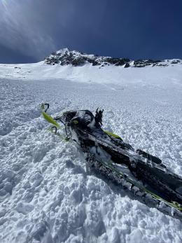
Triggering avalanches in dry snow is becoming less likely, but is still possible, particularly on wind-loaded, high elevation, shady slopes. On Wednesday, skiers in the northern Gallatin Range triggered some wind-loaded pockets breaking 6-8” deep (observation). Watch for shooting cracks as a clear sign that a wind drift hasn’t yet bonded. Before committing to steep slopes take a few minutes to stop, dig and test the upper couple feet of the snowpack to keep from getting surprised. Avalanches breaking deeper are much less likely, but it’s still good to keep the possibility in the back of your mind.
The avalanche danger is MODERATE this morning and will quickly rise to CONSIDERABLE as the day heats up.
Our last daily forecast of the season is Sunday, April 14.
If you get out please submit an observation. It does not need to be technical. Did you see any avalanches? How much snow is on the ground? Was the wind moving snow? Simple observations are incredibly valuable. You can also contact us by email (mtavalanche@gmail.com), phone (406-587-6984), or Instagram (#gnfacobs).
Upcoming Avalanche Education and Events
Hyalite Road Closure: Hyalite road is closed to ALL MOTORIZED VEHICLES until the morning of May 16. This is a regular annual road closure to reduce road damage during the spring thaw. Bicycle and foot traffic are allowed. Contact the Bozeman FS Ranger District for more info.
Events and Education Calendar.
Loss in the Outdoors is a support group for those affected by loss and grief related to outdoor pursuits. Check out the link for more information.
On Tuesday, April 9th, Doug Chabot wrote his final avalanche forecast for the Gallatin National Forest Avalanche Center. Doug, thank you for your friendship, mentorship and 29 years of service to Southwest Montana’s community. Congratulations on your fast approaching retirement!