Good morning. This is Ian Hoyer with the Gallatin National Forest Avalanche Forecast on Saturday, April 13th, at 7:00 a.m. Today’s forecast is sponsored by Klim and Cooke City Super 8/Bearclaw Bob’s. This forecast does not apply to operating ski areas.
Skies are blue and there is no new snow. Mountain temperatures are in the 30s and 40s F this morning. Winds are out of the southwest and west at 10-20 mph with 30-50 mph gusts. High temperatures today will be a few degrees warmer than yesterday, reaching well into the 50s F in many mountain areas. Winds will be 10-15 mph out of the southwest. Today will be mostly sunny, with chances for some thundershowers this afternoon, but no significant precipitation expected.

All Regions
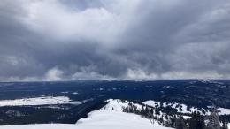
We’ve got another mostly sunny and really warm spring day on tap. Intermittent clouds may momentarily hit the pause button on melting, but as soon as the sun comes back out, rapid melting will resume.
Hazards associated with wet melting snow are the number one concern and they could take many forms. Loose wet slides will easily triggered as soon as the surface gets wet more than a few inches deep (photo). The deeper the wetting gets, the larger these slides could be. After two nights with either a minimal refreeze or none at all - the possibility of bigger, deeper, wider, more unpredictable wet slabs is starting to become a reality. I don’t expect them to be widespread today, but I also wouldn’t be surprised to hear that one broke. Cornices have been breaking off, which are a hazard by themselves (Sphinx photo), but they also make great triggers for slab avalanches (as this photo from Iceberg Peak demonstrates). Give cornices a wide berth as you’re traveling on ridgelines and minimize your time exposed below them. All of these concerns are greatest during the peak heat of the day, but with a minimal refreeze, warm temps and strong April sun, conditions will likely deteriorate by mid-morning. As soon as you can break through a surface crust into wet snow, or the surface is wet more than 6 inches deep, it’s time to get off steep sunny slopes - whether that means heading home or retreating to shady slopes.
Shady slopes that have stayed dry aren’t entirely immune from avalanche hazard. You may still be able to trigger a wind slab in a wind-loaded pocket or on weak layers in the upper couple feet of the snowpack. A quick snowpit and stability test can help keep you from getting surprised. A falling cornice may even be able to trigger an avalanche on the deeper weak layers which we haven’t seen activity on in weeks.
The avalanche danger is MODERATE first thing this morning and will quickly rise to CONSIDERABLE as the day heats up.
Our last daily forecast of the season is tomorrow, Sunday, April 14. We will continue to issue conditions updates on Mondays and Fridays and as needed through the rest of April.
If you get out please submit an observation. It does not need to be technical. Did you see any avalanches? How much snow is on the ground? Was the wind moving snow? Simple observations are incredibly valuable. You can also contact us by email (mtavalanche@gmail.com), phone (406-587-6984), or Instagram (#gnfacobs).
Upcoming Avalanche Education and Events
Hyalite Road Closure: Hyalite road is closed to ALL MOTORIZED VEHICLES until the morning of May 16. This is a regular annual road closure to reduce road damage during the spring thaw. Bicycle and foot traffic are allowed. Contact the Bozeman FS Ranger District for more info.
Events and Education Calendar.
Loss in the Outdoors is a support group for those affected by loss and grief related to outdoor pursuits. Check out the link for more information.
On Tuesday, April 9th, Doug Chabot wrote his final avalanche forecast for the Gallatin National Forest Avalanche Center. Doug, thank you for your friendship, mentorship and 29 years of service to Southwest Montana’s community. Congratulations on your fast approaching retirement!