Good morning. This is Dave Zinn with the Gallatin National Forest Avalanche Forecast on Tuesday, December 19th at 6:45 a.m. This information is sponsored by the Avalanche Alliance and the Idaho State Snowmobile Association - Avalanche Fund. This forecast does not apply to operating ski areas.
This morning, mountain temperatures are in the 20s F with 10-20 mph wind from the west to southwest. Stronger winds in the Centennial Mountain Range are gusting to 50 mph. There is no new snow. Today, temperatures will be in the 30s to low 40s F with 10-20 mph winds from the west to southwest. The mountains in Island Park and West Yellowstone may get a trace of snow overnight.

All Regions
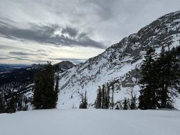
Maintain a heightened suspicion for avalanches on slopes steeper than 30 degrees. Persistent weak layers of faceted snow are buried 1-2 feet deep below a slab created during last week’s storm. This poor snowpack structure is found across the advisory area, resulting in many avalanches and signs of instability long after snowfall ended one week ago.
Yesterday at the Throne in the Bridger Range, my partner and I had variable pit results and no signs of instability. Still, we maintained our conservative travel plan because we focused on unstable results and the recent snowpack history (video). Last weekend, that history included a skier who remotely triggered an avalanche at Lionhead Ridge that broke downhill of him on a steep rollover (video). Alex and his partner triggered many whumphing collapses of the snowpack in Cooke City (video). Groups in Beehive Basin saw cracking around their skis, experienced collapses, and unstable test scores (details). Two groups of skiers north of Bridger Bowl aborted their travel plans when they heard loud collapses and got unstable test results (details1, details2). Follow our weather and avalanche log or the avalanche activity page for documentation of all the recent action, including a particularly interesting slide in Big Sky triggered by a mountain goat. Evidence at the scene led the Big Sky Ski Patrol to believe that no goats were harmed in the making of this avalanche (details, photo).
Due to the persistent weak layers in the snowpack, human-triggered avalanches are possible. These slides may break 1-2+ feet deep and widely across slopes. Triggering avalanches remotely (from a distance) makes areas immediately underneath steep slopes suspect. Develop a travel plan that avoids avalanche terrain or evaluate the snowpack and allow signs of instability such as cracking, collapsing, recent avalanches, and unstable test scores to turn your group back toward lower-angle slopes. If considering avalanche terrain, err towards areas without the added consequences of terrain traps.
The avalanche danger is MODERATE.
If you venture out, please fill an observation form. It does not need to be technical. Did you see any avalanches? How much snow is on the ground? Was the wind moving snow? Simple observations are incredibly valuable. You can also contact us via email (mtavalanche@gmail.com), phone (406-587-6984), or Instagram (#gnfacobs).
Upcoming Avalanche Education and Events
Our education calendar is full of awareness lectures and field courses. Check it out: Events and Education Calendar.
TODAY, December 18th, 6:00 pm, Free 1 hr Avalanche Awareness talk at REI, Bozeman.
We offer Avalanche Fundamentals with Field Session courses targeted towards non-motorized users in December and January and one geared towards motorized users in January. Sign up early before they fill up.
Loss in the Outdoors is a support group for those affected by loss and grief related to outdoor pursuits. Check out the link for more information.
Listen to GNFAC Forecaster Dave Zinn on the Hoary Marmot Podcast for some extracurricular avalanche talk (link to episode).