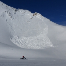
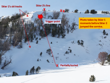
Advisory Archive
The mountains picked up a trace to one inch of new snow this morning. Temperatures are in the high teens to low 20s and winds are averaging 10-15 mph out of the west with gusts of 20-25. Light snowfall will continue today and tonight with accumulations of 1-2 inches by morning. Winds will remain moderate from the west and temperatures will rise into the high 20s this afternoon.


Over the last 24 hours, mountain temperatures reached the mid-30s F and wind has been out of the west-southwest with average speeds above 20 mph and gusts up to 40-50 mph. Temperatures this morning are in the teens to low 20s F and will reach the high 20s to low 30s F today. Wind will remain out of the southwest at 10-15 mph with gusts up to 20 mph. Snowfall will begin this evening and the mountains will receive 2-4” of snow by tomorrow morning. More snow is expected through Sunday with up to 8” in the mountains south of Bozeman and near Big Sky.
Yesterday was the first day in the past week without measurable snowfall. At 4 a.m. temperatures are near or above 30 F in the northern mountains, and are in the high teens F in the southern mountains. Overnight, wind in the northern ranges was out of the southwest at 10-15 mph with gusts in the 20s. Wind in the southern ranges was out of the west-northwest at 5-10 mph. Today will be warm and windy. Temperatures will reach the high 30s F in the northern mountains and will be in the high 20s F in the southern mountains. Wind will remain out of the southwest and increase this afternoon to 20-30 mph with gusts up to 40 mph. The next round of snow will begin Saturday afternoon.

Since yesterday morning most mountain locations received 2-4” of new snow while the Bridger Range received over 8” of high density snow. Over the last 24 hours winds were westerly at 10-20 mph with gusts over 30 mph. Temperatures this morning are in the single digits to low teens F and will rise to near 30 F in the northern mountains today. The southern mountains will be cooler with temperatures in the low 20s. Wind will be out of the west-southwest at 10-15 mph and skies will be partly sunny in the northern areas with more cloud cover in the southern areas. The next 48 hours will be warm and dry with the next chance for snow Saturday afternoon.
At 6 a.m. the mountains received 4 inches in the northern ranges and 6 inches in the south. It is still snowing and will drop another 4-6 inches by the time the storm shuts down later this afternoon. Winds have increased and are averaging 20-30 mph out of the west to southwest with gusts of 40 mph and will remain strong today. Mountain temperatures are near 20F and won’t warm much.

Snowfall yesterday totaled 5-7 inches in the Bridger and northern Gallatin Ranges and 3-5 inches everywhere else. In the last 24 hours winds have been west to southwest at 10-15 mph with gusts of 20 mph. This morning temperatures are in the low teens and will rise into the low 20s under mostly cloudy skies with winds forecasted to remain the same. Light snowfall will begin late tonight and drop 1-2 inches by morning. Scattered snow will continue into Wednesday.


Overnight the mountains south of Bozeman including Cooke City picked up 2-4 inches of new snow, while the Bridger Range remained dry. This morning, temperatures are in the upper teens to mid-20s F and winds are blowing 15-30 mph out of the W-SW. Today, light snow will continue to fall in the southern areas including Big Sky where an additional 1-3 inches is possible. Temperatures will warm into the mid to upper 20s and winds will continue to blow 15-30 mph out of the W-SW. Snow will taper off later in the day and tomorrow looks to be mostly dry. Another storm is forecasted to impact the area Tuesday night into Wednesday.


Overnight a fast but potent storm dropped 6-10 inches of low density snow in the mountains. At 4 a.m. snow appears to be tapering off, but the mountains could see an additional 1-2 inches by late morning. Currently, temperatures range from the mid-teens to low 20s F and winds are blowing 15-30 mph out of the W-NW with ridgetop gusts pushing 40 mph. Today, a break in the weather will allow temps to warm into the mid to upper 20s F under partly cloudy skies. Winds will continue to blow 15-30 mph out of the W-NW with stronger gusts along the ridgetops. No new snow is expected today, but another storm arrives tomorrow. The mountains could pick up 4-6 inches tomorrow into Tuesday.

Over the past 24 hours the mountains picked up 1-2 inches of new snow. This morning, temperatures are in the single digits to low teens F under mostly cloudy skies. Winds are blowing 10-20 mph out of the W-NW. Today, temperatures will warm into the low to mid-20s F and winds will continue to blow 10-20 mph out of the W-NW with gusts upwards of 30 mph possible along the ridgetops. A storm system approaching from the west will move into the area by mid to late afternoon. Snow will develop over the mountains and 1-2 inches is likely by this evening. Snow will continue through the night and the mountains should pick up 4-6 inches by tomorrow morning.
Over the last 24 hours the mountains picked up 1-2” of snow. Storm totals for the past 48 hours are 4-7” with reports from Cooke City stating 18” of low density snow fell in the mountains. Winds have been out of the west-southwest and decreased overnight to 5-15 mph with gusts reaching 20 mph. Over the last 24 hours, westerly wind gusts exceeded 30 mph in the mountains around Bozeman and Cooke City. Temperatures this morning are in the single digits F. Today, temperatures will be in the teens F. Wind will be out of the west-northwest at 5-15 mph. Skies will be mostly cloudy with light snow showers this afternoon. Greater snow accumulation is expected Saturday afternoon through Sunday.