Advisory Archive
A warm and windy weather pattern has set up over southwest Montana. At 4 am mountain temperatures are ranging from the high 20s to mid 30s and winds are out of the WSW at 20-40 mph. This strong SW flow did produce snow showers in the southern ranges.
Since yesterday morning the mountains around Cooke City have picked up .7 inches of SWE totaling 4-5 inches of snow while the mountains around West Yellowstone picked up 2-3 inches of new snow. The northern ranges picked up a trace to one inch. Today, mountain temperatures will rise into the mid to high 30s F and winds will continue to blow 20-40 mph out of the WSW. Winds will gradually decrease this evening and Thanksgiving looks to be a warm and pleasant day.


Since the last bulletin on Saturday morning the northern mountains have been dry while the southern areas got dusted with Cooke City getting two inches. Mountain temperatures have substantially warmed from the single digits to high teens as ridgetop winds blew westerly at 20-30 mph. By tomorrow, moist air on a west flow will bring some clouds and a trace to one inch of snow in the south as the northern mountains stays dry and mostly sunny. Temperatures will continue to warm today and Tuesday, but west winds will increase. The rest of the week looks dry and unimpressive for snowfall.
In the northern areas 2-3 inches of snow fell last night as temperatures plummeted to below zero. In the southern mountains 4-6 inches fell with temperatures dropping to the single digits. Winds have been averaging 10-15 mph out of the west with gusts hitting 30 mph. High pressure will build today and temperatures will climb towards normal in the next few days. Other than a few flurries this morning I’m not expecting more snow this weekend. Unfortunately, Thanksgiving week looks to be dry too.
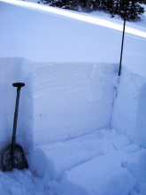
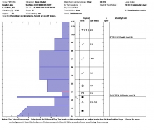
Since yesterday most areas received 6 inches of snow (0.6” of SWE); however, the mountains near Cooke City received 16 inches of snow (1.6” of SWE). This snow is relatively heavy and dense. Temperatures were in the teens F this morning. Winds calmed and were blowing 10-15 mph except in the Bridger Range where mid-mountain winds were blowing 15-25 mph from the S. Prior to this storm winds were blowing 20-40 mph, and they should increase again by this afternoon. Today, temperatures will remain in the teens and winds will blow 20-30 mph from the SW. The mountains near Cooke City should get another 6-8 inches of snow. All other areas should get 3-5 inches.
Over the past 48 hours intermittent weather disturbances have moved through southwest Montana producing heavy snow in some areas. The Shower Falls SNOTEL site in the northern Gallatin Range has recorded 1 inch of SWE totaling close to a foot of snow since Monday afternoon. The Bridger Range and mountains around Big Sky have picked up 4-6 inches over the past two days while the southern ranges received 1-2 inches. Currently, skies are clear and mountain temperatures are in the single digits above or below zero F. Winds are blowing 15-30 mph out of the WNW. Today a ridge of high pressure will build over the region producing clear skies and warmer temperatures. Highs today will climb into the mid 20s to low 30s F and winds will stay light to moderate out of the WNW. Conditions will begin to change tonight as another cold front approaches from the west.
Over the past 48 hours intermittent weather disturbances have moved through southwest Montana producing heavy snow in some areas. The Shower Falls SNOTEL site in the northern Gallatin Range has recorded 1 inch of SWE totaling close to a foot of snow since Monday afternoon. The Bridger Range and mountains around Big Sky have picked up 4-6 inches over the past two days while the southern ranges received 1-2 inches. Currently, skies are clear and mountain temperatures are in the single digits above or below zero F. Winds are blowing 15-30 mph out of the WNW. Today a ridge of high pressure will build over the region producing clear skies and warmer temperatures. Highs today will climb into the mid 20s to low 30s F and winds will stay light to moderate out of the WNW. Conditions will begin to change tonight as another cold front approaches from the west.
Over the past 48 hours intermittent weather disturbances have moved through southwest Montana producing heavy snow in some areas. The Shower Falls SNOTEL site in the northern Gallatin Range has recorded 1 inch of SWE totaling close to a foot of snow since Monday afternoon. The Bridger Range and mountains around Big Sky have picked up 4-6 inches over the past two days while the southern ranges received 1-2 inches. Currently, skies are clear and mountain temperatures are in the single digits above or below zero F. Winds are blowing 15-30 mph out of the WNW. Today a ridge of high pressure will build over the region producing clear skies and warmer temperatures. Highs today will climb into the mid 20s to low 30s F and winds will stay light to moderate out of the WNW. Conditions will begin to change tonight as another cold front approaches from the west.
A cold front pushed through yesterday morning dropping 6-7 inches of snow by noon. Last night another pulse dropped two more inches, except Cooke City which got closer to 4 inches. These snowfall amounts were measured at SNOTEL sites and ski area weather stations. Even more snow fell at higher elevations with 12” measured yesterday afternoon near Big Sky. Winds have been blowing steady and strong out of the west to northwest. They are averaging 20-30 mph with gusts exceeding 40 mph. Strong winds and scattered snow showers will continue into the middle of the week as mountain temperatures stay in the low 20s. Winter is here.
After last weekend's snow and a week of dry weather, more snow is coming today. 3-4 inches has already fallen in the mountains near West Yellowstone and Cooke City, and snowfall today should favor these areas. Yesterday ahead of this storm, winds increased and were blowing 20-50 mph from the S and SW. They have calmed slightly but should remain fairly strong through the weekend and slowly shift to the W and NW. Temperatures this morning are in the mid 20s F but should drop as the day progresses.
By Sunday morning the mountains throughout southwest Montana picked up 8-10 inches of new snow. The storm was cold and the snow that fell was low density powder measuring 5-6% with ridgetop winds out of the southwest at 10-20 mph. The next seven days are forecasted to be dry. Mountain temperatures are in the single digits this morning (well below average), but by Wednesday they are expected to rise into the high twenties.