Good Morning. This is Eric Knoff with the Gallatin National Forest Avalanche Advisory issued on Friday, January 26th at 6:45 a.m. Today’s advisory is sponsored by Mystery Ranch and Cooke City Super 8/Bearclaw. This advisory does not apply to operating ski areas.
A fast and furious storm yesterday afternoon dropped 3-5” of low density snow in most areas. Carrot Basin Snotel site in the southern Madison Range was the big winner picking up 7-8”. This morning snow has tapered off and temperatures are in the single digits to low teens F. Winds are blowing 15-35 mph out of the W-NW. Today, temps will warm into the upper teens to low 20’s F and winds will continue to blow 15-30 mph of the W-NW. There’s a chance for light snow showers this evening and the mountains could see 1-2” by tomorrow morning.

The Lionhead area has the weakest snowpack structure in the advisory area. Facets buried 1-2’ off the ground still hold the potential to propagate a fracture and produce large persistent slab avalanches (snowpit profile). The likelihood of triggering a slide on this layer is decreasing video, but the consequences remain high. Although conditions are gradually improving, careful snowpack evaluation and conservative decision making remain essential when traveling in steeper terrain.
Additionally, new snow and wind have formed thick wind slabs that will be touchy to human triggers. Stay clear of wind loaded slopes near the ridgelines and look out for cornices that have grown significantly over the past few weeks. Give these large overhanging chunks of snow a wide berth both above and below the ridgelines.
For today, the avalanche danger is rated CONSIDERABLE on all wind-loaded slopes and MODERATE elsewhere.
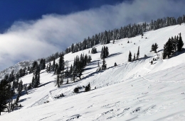
The combination of new snow and wind will make wind slabs today’s primary avalanche problem. Strong winds out of the west-northwest have formed sensitive wind drifts on leeward slopes (photo, photo). Winds have been strongest along the ridgelines, but have also worked their way into lower elevation terrain. Watch for pillows of wind drifted snow and avoid consequential terrain if there is evidence of recent wind loading.
A secondary concern is sugary facets 1-2’ off the ground. This layer is not widespread, but can be found in isolated areas (video). Doug got unstable results on this layer in the Taylor Fork on Sunday and skiers north of Bridger Bowl and in the southern Gallatin Range also got unstable test results on Wednesday. Variability between slopes is not unusual, so it’s important to evaluate individual slopes carefully before committing to avalanche terrain.
For today, new snow and wind is creating a CONSIDERABLE avalanche danger on wind-loaded slopes. All other slopes have a MODERATE avalanche danger.
If you get out and have any avalanche or snowpack observations to share, drop a line via our website, email (mtavalanche@gmail.com), phone (406-587-6984), or Instagram (#gnfacobs).
AVALANCHE FATALITY REPORT: Reas Peak, Centennial Range, 20 January
A full report on the avalanche that killed a snow biker on January 20th can be read here. The report has links to all supporting documentation (advisory, photos, video, maps).
King and Queen of the Ridge
King and Queen of the Ridge, Saturday, February 3rd. A Hike and Ski/Ride-a-Thon fundraising event to support the Friends of the Gallatin National Forest Avalanche Center. Sign up and start collecting pledges HERE.
Upcoming Avalanche Education and Events
BOZEMAN
Feb. 6th, Sidecountry specific avalanche awareness for family and friends. 6-8 p.m. @ Beall Park
Feb. 7th, Woman’s specific avalanche awareness, 6-7:30 p.m. @ REI in Bozeman
Feb. 7th, Avalanche awareness, 6-7:00 p.m. @ Roskie Hall MSU
Feb. 9 and 10, Companion Rescue Clinic, Info and Register
March 2nd, Avalanche Awareness, 6-7:00 p.m. Bozeman Split Fest
March 7th, Avalanche Awareness, 6-7:30 p.m. @ REI
DILLON
Feb. 24th and 25th, Snowmobile intro to avalanches w/ field course. More info: https://msuextension.org/conference/.
WEST YELLOWSTONE
Feb. 3rd, Avalanche Awareness, 7-8 p.m. at West Yellowstone Holiday Inn Conference Center
Feb. 10th, Avalanche Awareness, 7-8 p.m. at West Yellowstone Holiday Inn Conference Center
COOKE CITY
Every Friday and Saturday, Current Conditions Update and Avalanche Rescue, Friday 6:30-7:30 p.m. at The Antler's Lodge in January. Saturday anytime between 10-2 @ Round Lake.
Dashboard Talks, Episode 4: Doug Chabot and Eric Knoff talk about the questions they ask themselves about avalanches when they are in the backcountry regarding terrain and snowpack.