Good Morning. This is Eric Knoff with the Gallatin National Forest Avalanche Advisory issued on Thursday, March 22nd at 6:45 a.m. Today’s advisory is sponsored by Montana Alpine Guides and Cooke City Super 8/Bear Claw. This advisory does not apply to operating ski areas.
Overnight the mountains around Cooke City picked up 2-3” of new snow while the mountains around West Yellowstone and Big Sky picked up 1-2”. The mountains around Bozeman remained dry. This morning, temps range from the 20’s to mid-30’s F and winds are blowing 10-20 mph out of the W-SW with gusts around Hyalite and Big Sky breaking 30 mph. Today, the mountains could see light snow showers above 8,000 ft. with rain possible below that elevation. Temps will warm into the mid to upper 30’s F and winds will continue to blow 15-30 mph out of the W-SW. Heavier precipitation arrives later this evening. The mountains around Big Sky and West Yellowstone could see 3-5” by tomorrow morning. Cooke City will see 2-4” while the mountains around Bozeman will see 1-2”. The mountains could see rain up to 8,000 ft. this afternoon, but snow levels will drop to 6,000 ft. by tomorrow morning.

Yesterday, a skier triggered a small wind slab in Hyalite (video). It broke 6-12” deep, 30’ wide and occurred on an upper elevation, north facing slope. The slide was not large, but could have been dangerous if triggered in high consequence terrain. Isolated pockets of wind drifted snow are mainly confined to upper elevation slopes below ridgelines and cliff bands. The slide yesterday is a good reminder that human triggered avalanches remain possible on wind loaded slopes.
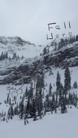
Cornices are also a significant problem. On Tuesday, a snowmobiler in the Centennial Range south of West Yellowstone was injured when a cornice broke under his feet, which sent him tumbling down hundreds of feet over a cliff (photo). Click the link below for a more detailed report. Give cornices a wide distance along the ridgelines and don’t spend too much time on slopes below (photo).
An additional problem today will be wet snow avalanches. Above freezing temperatures and the possibility of rain will increase the wet snow avalanche danger as the day progresses, mainly below 8,000 feet. Yesterday, a skier on Yellow Mountain near Big Sky observed an old wet loose avalanche that occurred during last week’s warm up (photo). Similar avalanches could be possible today on steep, mid to low elevation slopes. If the upper layers of the snowpack start to feel soft, damp and unconsolidated it will best to avoid steeper terrain. Rain is a sure tell sign it’s time to leave the backcountry.
Today, the dry snow avalanche danger is rated MODERATE on wind loaded slopes and LOW on non-wind loaded slopes. The wet snow avalanche danger will start out LOW, but rise to MODERATE on slopes below 8,000 ft.
If you get out and have any avalanche or snowpack observations to share, drop a line via our website, email (mtavalanche@gmail.com), phone (406-587-6984), or Instagram (#gnfacobs).
Cornice Fall, Centennial Mountains, ID
On Tuesday, March 20, a snowmobiler walked to edge of the ridge and broke a cornice. He tumbled to the bottom and was injured and air evacuated out. A report of the accident is HERE.
Send us your observations on Instagram! #gnfacobs
Posting your snowpack and avalanche observations on Instagram (#gnfacobs) is a great way to share information with us and everyone else this spring.
Cooke City is buried with snow this winter. Sam Wilson of the Billings Gazette wrote an article on the potentially record busting season (article).