Good Morning. This is Doug Chabot with early season avalanche and weather information from the Gallatin National Forest Avalanche Center on Wednesday, November 28th at 6:30 a.m. This bulletin is sponsored by Spark R&D and World Boards. We will start issuing daily avalanche forecasts with danger ratings this Friday.
At 5 a.m. all the mountains except the Bridger Range are reporting snowfall. Big Sky to West Yellowstone has 3” with 1-2” in Hyalite and Cooke City. Mountain temperatures are near 20F and winds are 15-30 mph with gusts of 40 mph from the W-SW. Snowfall will add another 2-4” by tomorrow morning with Cooke City getting closer to 6”. Winds will remain the same and temperatures will rise into the low 30s under mostly cloudy skies. Thursday looks to be partly cloudy with moderate SW winds and temperatures hitting the 30s.

Since Thanksgiving, over a foot of snow (1+” SWE) fell with strong west to southwest winds. Folks saw a few natural avalanches up Hyalite (photo), and in the Bridger Range (report), while skiers in Bear Basin in the northern Madison Range triggered a wind slab that they captured on video. Avalanches were not widespread and were confined to the new snow. This matches our findings from the field which Alex describes in a video from Middle Basin (north of Big Sky) as well as snowpit profiles recently dug throughout our forecast area.
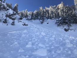
The underlying snowpack is generally strong and our primary concern is with today’s new snow. Snow and wind will create thick wind-drifts near the ridgelines which will be easily triggered. Recent avalanches or cracking (photo) of this new snow are signs of a rising avalanche danger. Stay out of avalanche terrain if you witness these warnings.
The snowpack in the Lionhead area outside West Yellowstone is shallow, weak and unstable. Alex was there on Monday and found a 2’ deep snowpack that consisted of sugary grains of facets capped by 6” of new snow (photo). His video shows the crumbly nature of the facets and their inability to support much new snow. With today’s snowfall and wind a skier or rider can trigger an avalanche, especially at the ridgelines where wind-drifts will be thick and unstable.
New this season, we added hyperlinks to the Weather and Avalanche Log and a new Menu item <Avalanches and SnowPits> with information on avalanche activity and incidents.
If you get out and have any avalanche or snowpack observations to share, contact us via our website, email (mtavalanche@gmail.com), phone (406-587-6984), or Instagram (#gnfacobs).
Upcoming Avalanche Education and Events
Our education calendar is full of awareness lectures and field courses. Check it out: Events and Education Calendar.
TONIGHT! November 29, 30 and Dec 1, 2or 8, Intro to Avalanche w/ Field Day, more info here
December 1, Klim Winter Kick-Off and avalanche awareness, Rigby, Idaho
December 5, 1-hr Avalanche Awareness, 6-7pm at REI, Bozeman
December 6, 1-hr Avalanche Awareness and Beacon Practice, 6:30-8pm at Story Mill Park
COOKE CITY
Every Friday and Saturday, Rescue Training and Snowpack Update. Friday 6:30-7:30 p.m at the Soda Butte Lodge. Saturday anytime between 10-2 @ Round Lake.
Check out our new “Avalanches and Snowpits” menu item where we list all the reported avalanche activity.