Good Morning. This is Alex Marienthal with the Gallatin National Forest Avalanche Forecast issued on Sunday, December 2nd at 7:30 a.m. This Forecast is sponsored by Cooke City Super 8/Bearclaw Bob’s and Werner Wealth Management. This forecast does not apply to operating ski areas.
The mountains did not get any new snow since early yesterday morning. Wind was 5-15 mph out of the southwest yesterday, and is east-southeast at 0-10 mph this morning. Temperatures are single digits to low teens F this morning, and will be in the high teens to low 20s F today. Wind will remain light at 0-10 mph out of the southeast to east. Today will be partly sunny with a trace of snow possible this evening, then cold and dry the rest of this week.

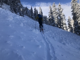
The mountains got 3-5” of low density snow early yesterday morning and 3-4” a few days ago. Yesterday, skiers in Hyalite and Beehive reported 10” of light, new snow above 9,000’. Eric and I went to Saddle Peak near Bridger and found fresh drifts that easily cracked under our skis (photo, photo), which prompted us to change our plan to more conservative terrain (video).
Today, avalanches in the recent new snow are less likely and generally small. The snowpack below the recent snow is mostly stable and lacks widespread weak layers, and avalanches deeper than the recent snow are unlikely (photo, video). However, it is always essential to carefully assess the snowpack and the consequences of terrain before riding steep slopes. A small avalanche can be deadly in the wrong spot. Light wind today will not create many fresh slabs, but some may linger from yesterday or form in isolated areas today. Be on the lookout for wind-drifted snow near ridgelines, edges of gullies, and below rock outcrops.
A generally stable snowpack with minimal wind and light snow makes avalanche danger today LOW.

The Lionhead area near West Yellowstone has a weak snowpack with sugary facets in the bottom half (photo, video). Recent snow and wind have been light, but were enough to create an unstable snowpack on some slopes. The most likely slopes to avalanche are wind loaded slopes where a thicker slab of snow rests over the weak base. Cracking and collapsing of the snowpack are clear signs the snowpack is unstable and to avoid avalanche terrain. Avalanches breaking on this sugary, weak snow could be large and wide. The best defense is to avoid riding on and below slopes steeper than 30 degrees. Today, large avalanches are possible to trigger and avalanche danger is MODERATE.
New this season, we added hyperlinks to the Weather and Avalanche Log and a new Menu item <Avalanches and SnowPits> with information on avalanche activity and incidents.
If you get out and have any avalanche or snowpack observations to share, contact us via our website, email (mtavalanche@gmail.com), phone (406-587-6984), or Instagram (#gnfacobs).
Upcoming Avalanche Education and Events
Our education calendar is full of awareness lectures and field courses. Check it out: Events and Education Calendar.
BOZEMAN
December 5, 1-hr Avalanche Awareness, 6-7 p.m. at REI, Bozeman
December 6, 1-hr Avalanche Awareness and Beacon Practice, 6:30-8 p.m. at Story Mill Park
December 11 and 12, Snowmobile Intro to Avalanches w/Field, Holiday Inn, West Yellowstone; more info here
December 12, 1-hr Avalanche Awareness for Snowmobilers, 6-7 p.m. at Yellowstone Motorsports, Bozeman
December 13, 1-hr Avalanche Awareness, 6-7 p.m. at Play It Again Sports, Bozeman
HELENA
December 12, 1-hr Avalanche Awareness, 6-7 p.m. at The Basecamp, Helena
COOKE CITY
Every Friday and Saturday, Rescue Training and Snowpack Update. Friday 6:30-7:30 p.m at the Soda Butte Lodge. Saturday anytime between 10-2 @ Round Lake.
Check out our new “Avalanches and Snowpits” menu item where we list all the reported avalanche activity.