Bye-bye winter, hello spring. This is Doug Chabot with the Gallatin National Forest Avalanche Forecast issued on the spring equinox, aka Wednesday, March 20th at 6:45 a.m. Today's forecast is sponsored by Grizzly Outfitters in partnership with the Friends of the Avalanche Center. This forecast does not apply to operating ski areas.
Under clear skies mountain temperatures dropped to the high 20s last night after reaching the mid-40s yesterday. Winds are easterly at 5-10 mph. Today will be sunny with light southeast wind. Mountain temperatures are forecasted to break 50F for the first time this season.

All Regions
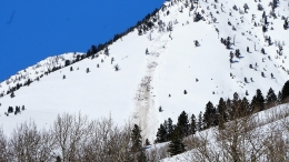
My hackles are up. Wet avalanches are on my radar. Yesterday, I saw large wet loose slides in Gallatin Canyon that gouged to the dirt on south facing slopes. In Bacon Rind the low elevation snowpack was fully moist and broke twice in my stability tests (ECTP 12 and 13) on facets near the ground (video). This was unexpected. Slopes that are sunny, wet, shallow (3-4 feet) and faceted are the most susceptible to avalanching. Most low elevation, southerly facing slopes fit this bill. This is the first time water has hit facets near the ground, and the snowpack does not like firsts. Rapid change creates instability. Wet loose avalanches can gouge to the dirt (photo), and wet slabs could propagate across a slope. Slopes will start out with a thick, frozen crust that will warm and melt by late morning, a process Ian describes in this video from Cooke City.
A word of caution: Low elevation, south facing slopes are on the commute to and from higher, dryer terrain. These slopes will be especially dangerous during exit later in the afternoon when we may not be the most attentive.
During my tour I dug on an east facing slope at 8,900 feet. A 3” thick ice crust capped the slope and under it the snow was dry and cold (-5C, 20 cm down). On slopes that are not getting very wet from sun, avalanches are unlikely. For today, the avalanche danger will start out LOW but rise to MODERATE as the sun and temperatures climb.
If you get out and have any avalanche or snowpack observations to share, contact us via our website, email (mtavalanche@gmail.com), phone (406-587-6984), or Instagram (#gnfacobs).
Spring is here and wet snow avalanches are becoming a daily concern. Anticipate decreasing stability while forming a travel plan. This article from Backcountry Magazine highlights some things look for that indicate when it is time to turn around.