Good morning. This is Dave Zinn with the Gallatin National Forest Avalanche Forecast on Monday, March 21st at 7:00 a.m. This information is sponsored by Highline Partners and Spark R&D. This forecast does not apply to operating ski areas.
This morning, mountain temperatures are in the single digits above and below zero degrees F with 5-15 mph winds from the west to northwest. The mountains around Bozeman and Big Sky received 3-5” of new snow in the last 24 hours and the mountains near West Yellowstone and Cooke City received 1-2”. Today, temperatures will rise to the upper 20s to mid 30s F with 5-15 mph winds from the west to southwest. Some areas may get a trace of snow tonight.

All Regions
The 48-hour storm total in the mountains around Bozeman and Big Sky is 6-10” equal to 0.6-0.8” of snow water equivalent (SWE) with 2-5” (0.2-0.3” SWE) near West Yellowstone and Cooke City. Winds remained light through the storm, exceptions to this are periods of moderate winds in the Bridger and North Gallatin Range and the mountains near Cooke City.
With higher storm totals, new snow avalanches will be deeper and more dangerous near Bozeman and Big Sky. Skiers in Hyalite Canyon and the Beehive Basin area saw natural avalanches that failed yesterday below the new snow (Hyalite photo and details, Beehive details). The Big Sky Ski Patrol reported the storm snow was “extremely sensitive” to triggers. This weekend’s snow remains a concern today. Additionally, as temperatures climb this afternoon, the recent snow will be more likely to slide on slopes getting hit by the spring sun.
Slopes across the advisory area with recent drifts of wind-loaded snow are suspect. Yesterday, the Bridger Bowl Ski Patrol noted that the wind was rapidly forming slabs near ridgelines and under cliffs that readily broke 6-18” deep. This weekend sections of cornice broke and triggered avalanches near Lionhead (video, photos and details) and in the Republic Creek drainage (photo and details). Last week, similar avalanches failed on Saddle Peak, Buck Ridge and Mount Blackmore. Treat slopes commonly loaded by the wind and near ridgelines with added caution.
Large avalanches are possible due to persistent weak layers buried 1-3’ deep on many slopes. On Saturday, skiers in Bear Basin made a hasty retreat after they triggered an audible collapse in the snowpack (details). Last week, natural avalanches broke on Crown Butte and Miller Mountain, skiers triggered a slide near Mount Abundance and a natural avalanche broke an estimated 1,000’ wide on Cedar Mountain. See these and all reported avalanche activity on our activity log.
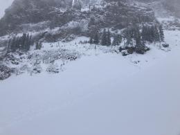
This adds up to tricky avalanche conditions. Many slopes are stable, similar to what Doug and I found at the Throne yesterday (video), but safe travel in and around avalanche terrain requires thorough snowpack assessments and a willingness to heed warning signs if you observe indicators of instability. Human-triggered avalanches are possible, and the danger is MODERATE.
If you get out, please send us your observations no matter how brief. You can submit them via our website, email (mtavalanche@gmail.com), phone (406-587-6984), or Instagram (#gnfacobs).
Yesterday, March 19, two skiers were caught and one was killed in an avalanche near Steamboat Springs, Colorado (preliminary details). This was the fourth avalanche fatality in the U.S. in the past week and the fifteenth this season (https://avalanche.org/avalanche-accidents/).