Good morning. This is Ian Hoyer with the Gallatin National Forest Avalanche Forecast on Friday, April 8th at 7:00 a.m. This information is sponsored by Gallatin Valley Snowmobile Association, Cooke City Motorsports and Beartooth Powder Guides. This forecast does not apply to operating ski areas.
Temperatures are in the high 20s and low 30s F this morning. Skies are clear and winds are 10-20 mph out of the west. Mountain temperatures will climb into the 40s, 50s, and even low 60s F this afternoon. Moderate winds will shift slightly to the southwest. Tomorrow will be much cooler and cloudier with a chance for light snowfall.

All Regions
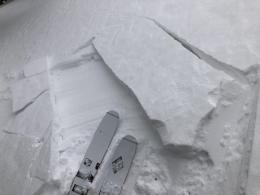
Wet avalanches are the primary hazard today. Mountain temperatures are already near or above freezing this morning and they’re just going to climb higher today. Thin crusts that formed overnight will break down quickly as temperatures rise. As the snow surface gets wet, you’ll be able to trigger wet loose avalanches in the snow that fell earlier in the week. Alex and I found these conditions beginning to develop near Cooke City yesterday and with temperatures 10 or more degrees warmer today, wet avalanches will be even more of a concern (video). The snow surface becoming damp and roller balls or pinwheels running downhill below you are clear signs that the wet snow avalanche danger is on the rise. These conditions will develop after just a few hours of sunshine. Wet snow avalanches will generally not break deeper than the snow that fell earlier in the week, which means that the more new snow there is, the larger and more dangerous these loose slides will be. Don’t discount the danger of loose snow avalanches, they can entrain a surprising amount of snow and easily push you into rocks or trees or bury you in a gully.
Avalanches breaking in dry snow do remain possible, particularly on slopes with wind drifted snow from earlier in the week (photo, photo). If you’re seeking out shady, high elevation slopes, watch for cracking wind drifts and dig down to make sure you don’t get surprised by unstable weak layers 1-3 ft deep (video). Also, don’t forget about small, low elevation slopes you’ll have to cross in the afternoon on the way back to the trailhead. It’s easy to get caught off guard by these low elevation slopes that don’t pose much of a hazard during typically winter conditions.
The avalanche danger is MODERATE today.
Our last daily forecast will be issued on Sunday. During the rest of April we will issue weather and avalanche updates Monday and Friday. Please continue sending us your observations. You can submit them via our website, email (mtavalanche@gmail.com), phone (406-587-6984), or Instagram (#gnfacobs).
Our final daily avalanche forecast of the 2021-22 season will be this Sunday, April 10th. Thank you to everyone who has followed the forecasts, submitted field observations and donated to the Friends of the Avalanche Center. We are grateful to be a part of your winter. We will continue to provide avalanche updates every Monday and Friday through April.