Good Morning. This is Doug Chabot with the Gallatin National Forest Avalanche Advisory issued on Tuesday, December 19th at 7:00 a.m. Today’s advisory is sponsored by Cooke City Super 8/Bearclaw Bob’s and Gallatin Valley Snowmobile Assoc. This advisory does not apply to operating ski areas.
At 5 a.m. the mountains around Cooke City received 1-2” of new snow. Under cloudy skies winds are W-SW at 25-40 mph in the northern ranges and 10-25 mph in the south with temperatures in the high teens to mid-20s. Today is unsettled with chances of snow increasing throughout the day. By tomorrow morning I expect 2-4” in the north and 6-8” in the south with the storm continuing through Wednesday. Winds will remain westerly and average 20-30 mph as temperatures cool into the teens tonight.

Strong wind yesterday in the northern mountains built wind slabs 1-2 feet thick that were triggered by ski patrols, and avalanched naturally on Mt. Blackmore (photo) and in Beehive Basin (photo). The slides were small and only involved the new, wind-drifted snow. Winds were variable in speed and direction and loaded slopes at the ridgeline and cross-loaded slopes in gullies mid-mountain (photo). Today, more wind and new snow will make wind slabs easy to trigger.
Snowfall today will further bury and stress a weak layer of faceted snow buried 5-10” under the surface. This problematic layer formed during sunny weather a week ago and will begin to crack, collapse and possibly avalanche with more snow in the coming days, which Alex explains in a video he made up Hyalite (video).
Natural and human triggered slides on wind-loaded slopes yesterday, plus continued wind today, point to a CONSIDERABLE danger on all wind-loaded terrain and MODERATE on all other slopes.

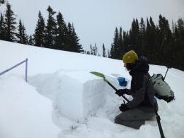
In the southern mountains the wind has not been very strong, but this may change with today’s storm. At Lionhead on Friday, Eric found a thin, weak and faceted snowpack (snowpit profile) which will become unstable with more snow. Outside Cooke City the snowpack is 4-6’ deep and stable, but on Sunday I found a weak layer of sugary facets 4-6” under the surface that will produce avalanches when loaded with more snow or wind slabs (photo, video). For today the avalanche danger is rated MODERATE, but could rise to CONSIDERABLE with today’s storm. This means that the ability to trigger avalanches will rise from possible to likely.
If you get out and have any avalanche or snowpack observations to share, drop a line via our website, email (mtavalanche@gmail.com), phone (406-587-6984), or Instagram (#gnfacobs).
Upcoming Avalanche Education and Events
BOZEMAN
Dec. 21, Avalanche Awareness, 6-7:30 P.m. at Play It Again Sports, Bozeman
Jan. 12 and 13, Companion Rescue Clinic, Info and Register
Jan. 17, 18 and 20 or 21, Introduction to Avalanches w/ Field Day, Info and Register Here
Jan. 24, 25 and 27, Advanced Avalanche Workshop w. Field Day, Info and Register Here
Feb. 9 and 10, Companion Rescue Clinic, Info and Register
WEST YELLOWSTONE
Today and tomorrow, Snowmobiler Introduction to Avalanches with Field Course, Info and Register Here
Jan. 6, Avalanche Awareness, 7-8 p.m. at West Yellowstone Holiday Inn Conference Center
COOKE CITY
22 and 23 December, Weekly Current Conditions and Avalanche Rescue, 6:30-7:30 p.m. Friday @ the Super 8, and anytime between 10-2 on Saturday @ Lulu Pass road.
Check out Chabot’s article, Being Prepared that was just published in the Chronicle’s CARVE magazine this weekend. In essence, preparation decreases the chance for negative outcomes.