Good Morning. This is Alex Marienthal with the Gallatin National Forest Avalanche Advisory issued on Sunday, January 28th at 6:45 a.m. Today’s advisory is sponsored by Knoff Group Real Estate and Swiss Fit Montana. This advisory does not apply to operating ski areas.
At 4 a.m. the mountains near Cooke City have 8” of new snow, near West Yellowstone has 3-4”, Big Sky and Hyalite have 1-2”, and the Bridger Range has none. Temperatures are teens to low 20s F and wind is west-southwest at 25-30 mph with gusts over 50 mph. Today is partly cloudy with continued light snowfall in the southern mountains, temperatures in the 20s F, and west-northwest wind at 25-35 mph. By tomorrow the mountains will get 3-5” near Cooke City and West Yellowstone and 1” elsewhere.

The mountains near Cooke City got 8” of new snow equal to .6” snow water equivalent (SWE), and near West Yellowstone and the southern Madison and Gallatin ranges got 3-4” of new snow equal to .3-.4” SWE. Strong winds drifted this light powder into dense slabs 1-3’ thick that are easy to trigger. Avoid large pillows of snow on steep slopes and near ridgelines. Stay far back from the edge of large cornices along ridgelines, and avoid slopes below them. Ski and ride in terrain sheltered from the wind.
Almost a foot of low density snow near Cooke City makes dry loose avalanches and storm slabs possible. Avoid steep slopes if you experience collapsing or see shooting cracks across the snow surface.
Avalanches breaking 3-5' deep on a layer of weak facets are becoming difficult to trigger, but are large and destructive (photo, video). This weak layer of facets 1-2’ off the ground is particularly dangerous and unstable in the Lionhead area near West Yellowstone (video, photo). Be extra cautious of steep slopes and runout zones below. If necessary to cross avalanche terrain never expose more than one person at a time.
Avalanche danger today is CONSIDERABLE on wind loaded slopes and MODERATE on all other slopes.

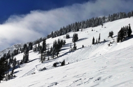
The mountains near Bozeman and Big Sky got 1-2” of new snow since yesterday and 4-6” since Thursday. Strong west-southwest wind drifted this snow into slabs 1-2’ thick that are possible to trigger near ridgelines and along the edges of cliffs and gullies. Avoid steep terrain if you see cracking or collapsing of fresh drifts. Avoid terrain traps like cliffs, trees, and confined gullies to minimize the consequences of being caught in any size slide.
Avalanches breaking deeper than fresh wind slabs are not likely, but possible in specific terrain. A buried layer of sugary, weak facets 1-2’ off the ground can produce large avalanches, and it is most unstable where the snowpack is relatively shallow or highly variable. Careful snowpack evaluation is essential before riding any steep slope. On Friday I found an isolated weak layer of surface hoar that was only visible after it produced an unstable result in a stability test (video), which gave good reason to ride different or low angle terrain.
Strong wind and recent snow make avalanche possible and avalanche danger today is MODERATE.
If you get out and have any avalanche or snowpack observations to share, drop a line via our website, email (mtavalanche@gmail.com), phone (406-587-6984), or Instagram (#gnfacobs).
AVALANCHE FATALITY REPORT: Reas Peak, Centennial Range, 20 January
A full report on the avalanche that killed a snow biker on January 20th can be read here. The report has links to all supporting documentation (advisory, photos, video, maps).
King and Queen of the Ridge
King and Queen of the Ridge, Saturday, February 3rd. A Hike and Ski/Ride-a-Thon fundraising event to support the Friends of the Gallatin National Forest Avalanche Center. Sign up and start collecting pledges HERE.
Upcoming Avalanche Education and Events
BOZEMAN
Feb. 6th, Sidecountry specific avalanche awareness for family and friends. 6-8 p.m. @ Beall Park
Feb. 7th, Woman’s specific avalanche awareness, 6-7:30 p.m. @ REI in Bozeman
Feb. 7th, Avalanche awareness, 6-7:00 p.m. @ Roskie Hall MSU
Feb. 9 and 10, Companion Rescue Clinic, Info and Register
March 2nd, Avalanche Awareness, 6-7:00 p.m. Bozeman Split Fest
March 7th, Avalanche Awareness, 6-7:30 p.m. @ REI
PHILLIPSBURG
Feb. 8th, Avalanche Awareness,
DILLON
Feb. 24th and 25th, Snowmobile intro to avalanches w/ field course. More info: https://msuextension.org/conference/.
WEST YELLOWSTONE
Feb. 3rd, Avalanche Awareness, 7-8 p.m. at West Yellowstone Holiday Inn Conference Center
Feb. 10th, Avalanche Awareness, 7-8 p.m. at West Yellowstone Holiday Inn Conference Center
COOKE CITY
Every Friday and Saturday, Current Conditions Update and Avalanche Rescue, Friday 6:30-7:30 p.m. at The Soda Butte Lodge in February. Saturday anytime between 10-2 @ Round Lake.
Dashboard Talks, Episode 4: Doug Chabot and Eric Knoff talk about the questions they ask themselves about avalanches when they are in the backcountry regarding terrain and snowpack.