Good Morning. This is Doug Chabot with the Gallatin National Forest Avalanche Advisory issued on Tuesday, February 27th at 6:45 a.m. Today’s advisory is sponsored by the 36th annual Pinhead Classic, a telemark ski race held at Bridger Bowl this Saturday. This advisory does not apply to operating ski areas.
Call in sick today, because in the last 24 hours it dumped 22” of fluffy powder at Bridger Bowl (15” yesterday + 7” last night), near 10” at Big Sky, 6-8” around Cooke City and West Yellowstone, and at least 2” everywhere in between. At 5 a.m. it is still snowing in the northern ranges which should end soon, but then again it wasn’t supposed to snow that much to begin with, so all bets are off. Winds were remarkably calm yesterday, but not anymore: they are averaging 20-25 mph with gusts of 35-50 mph out of the W-SW. Temperatures will rise from the single digits to teens today with clouds increasing and winds turning west and remaining strong.

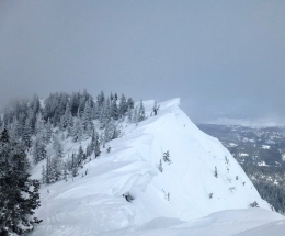
Today's avalanche concern is quite simple: it is windy with a lot of low density powder to blow around. Wind-loading is our #1 concern (and #2 and #3). Winds are blowing strong at ridgelines and also at lower elevations. The snow was measured at 4% density (96% air, aka cold smoke powder) and a mere puff of wind will blow this into thicker drifts (wind slabs). I expect slopes that are wind-loaded will easily avalanche with a human trigger and some will even break naturally. Look for wind slabs at ridgelines and gullies, on all aspects and elevations, and avoid them.
On slopes without a fresh wind-load, the snowpack is mostly strong and stable. On Sunday, Eric found stable conditions above Hebgen Lake (video) and I found wind slabs on top of a stable snowpack (video) at Lionhead. In the last few days, skiers and riders around Cooke City, Bacon Rind, Beehive, Hyalite and the Bridger Range have also found safe avalanche conditions.
I am lumping all the mountain ranges together even though snowfall amounts differ. In areas where SNOTEL only measured a couple inches, there may be much more at higher elevations based on what happened around Bridger Bowl and Big Sky.
Do not get on or underneath wind slabs. If you see shooting cracks in front of your skis or sled it might be too late. Just stick to the powder and you’ll have a good day. Additionally, wherever the new snow is deep, loose snow avalanches may unexpectedly knock you down and carry you into dangerous terrain. Throughout our advisory area the avalanche danger is rated CONSIDERABLE on all wind-loaded slopes and MODERATE on all others.
If you get out and have any avalanche or snowpack observations to share, drop a line via our website, email (mtavalanche@gmail.com), phone (406-587-6984), or Instagram (#gnfacobs).
Upcoming Avalanche Education and Events
BOZEMAN
Feb. 28th, Know Before You Go avalanche awareness, 7:00 p.m. @ Procrastinator Theater, MSU
March 2nd, Avalanche Awareness, 7-8:00 p.m., MAP Brewing Bozeman Split Fest
March 2nd and 3rd, SheJumps Companion Rescue Clinic, Info and Register HERE
March 3rd, Pinhead Classic at Bridger Bowl. Ski race, awards and legendary after party. Info HERE.
March 7th, Avalanche Awareness, 6-7:30 p.m. @ REI
LIVINGSTON
March 20, Beer for a Cause Night at Katabatic Brewing, 4-8p.m. A dollar from every pint will be donated to The Friends of the Avalanche Center.
COOKE CITY
Every Friday and Saturday, Current Conditions Update and Avalanche Rescue, Friday 6:30-7:30 p.m. at The Soda Butte Lodge in February. Saturday anytime between 10-2 @ Round Lake.
In Dashboard Talks, Episode 7, Alex Marienthal and Doug Chabot provide a few thoughts about why you should read the daily advisory. As the season wears on, don't get "Advisory Fatigue." There is a lot of winter still to come!