Good Morning. This is Doug Chabot with the Gallatin National Forest Avalanche Advisory issued on Wednesday, March 7th at 6:30 a.m. Today’s advisory is sponsored by Yellowstone Arctic Yamaha and Yamaha Motor Corp in partnership with the Friends of the Avalanche Center. This advisory does not apply to operating ski areas.
Under clear skies, mountain temperatures are in the single digits to low teens with winds 10-15 mph out of the W-SW. Today will be sunny and temperatures will warm into the mid-30s with light winds. No snow is expected until Friday. Today will be our first day of warm, spring-like weather this season.
A factoid from the Yellowstone Club: at the Timberline Wx station (9400’) the temperature has only been above freezing for 12 hours since skiing started in December. The last time above 32F was on January 16th.

Without new snow or wind-loading, the likelihood of triggering avalanches is decreasing. Yesterday, a skier triggered a very small and thin avalanche in the new snow around Cooke City (photo), and another party triggered a wind-loaded pocket in a gully near Bacon Rind on the east side of the highway (photo). These instabilities are isolated and will be even more difficult to trigger today. Yesterday, I rode and skied up Buck Ridge south of Big Sky and found stable snow (video) which is also what Eric found in the Bridger Range.
Even with generally stable and safe conditions, avalanches are not impossible to trigger. Today there are three things to remember:
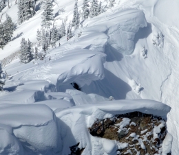
- Cornices are huge (photo) and will break far from the edge, triggering a slope and/or crushing you along the way. Eric’s video from his trip to the Bridger Range yesterday highlights this danger.
- Above freezing temperatures will melt the top few inches of low-density powder and create wet-loose avalanches, also known as point release slides. These will be on steep, south-facing slopes getting full sunshine. They will not be big, but they may knock you over, twist a knee, or push you off a cliff. Pinwheels of snow are a sign the snow is getting wet enough to slide.
- Previously wind-loaded slopes may have small pockets that could avalanche.
For today, triggering avalanches in unlikely and the danger is rated LOW on all slopes in our advisory area. The definition of Low includes “small avalanches in isolated areas or extreme terrain”, so do not turn off your brain.
If you get out and have any avalanche or snowpack observations to share, drop a line via our website, email (mtavalanche@gmail.com), phone (406-587-6984), or Instagram (#gnfacobs).
Upcoming Avalanche Education and Events
BOZEMAN
TONIGHT!!, Avalanche Awareness, 6-7:30 p.m. @ REI
LIVINGSTON
March 20, Beer for a Cause Night at Katabatic Brewing, 4-8p.m. A dollar from every pint will be donated to The Friends of the Avalanche Center.
COOKE CITY
March 10th, Upper Yellowstone Snowmobile Club Annual Hog Roast, Cooke City, festivities from 7am – 7pm. Schedule Here.
Friday and Saturday, Current Conditions Update and Avalanche Rescue, Friday 6:30-7:30 p.m. at The Soda Butte Lodge. Saturday anytime between 10-2 @ Round Lake.
In the last 2 weeks there have been 6 avalanche fatalities: 2 snowshoers and 3 snowmobilers in WA, and 1 snowboarder in AK. Our snowpack is a lot more stable than other areas of the west, but let’s not let our guard down. More info on the accidents is here: https://avalanche.org/avalanche-accidents/