Good Morning. This is Eric Knoff with the Gallatin National Forest Avalanche Advisory issued on Friday, March 9th at 6:30 a.m. Today’s advisory is sponsored by Mystery Ranch and World Boards. This advisory does not apply to operating ski areas.
Over the past 24 hours the mountains around Big Sky, West Yellowstone and Cooke City picked up 2-4” of new snow. The mountains around Bozeman remained mostly dry. At 5 a.m. temps range from the teens to mid-20’s F and wind are blowing 15-30 mph out of the W-SW. Today, highs will warm into the upper 20’s to low 30’s F and winds will continue to blow 15-30 mph out of the W-SW. There will be a quick break in the weather this morning, but snow returns this afternoon and evening. By tomorrow morning the southern mountains will see 2-4” of new snow while the north will see 1-2”.

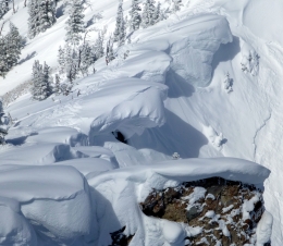
The Bridger Range got completely missed by the weak storm that impacted the mountains south of Bozeman. The snowpack is generally stable and likelihood of triggering a slide is low. The main concern in the Bridger Range is large cornices. Give these monsters amply distance along the ridgelines and limit exposure time on slopes below (video, photo).
Today, natural and human triggered avalanches are unlikely and the avalanche danger is rated LOW.

A fast-moving storm dropped 2-4” of snow in the mountains south of Bozeman including Cooke City. This quick shot of snow was accompanied by winds gusting 40+ mph out of the W-SW. The combination of new snow and strong winds formed fresh wind slabs in upper elevation terrain.
Today, wind slabs will be the primary avalanche concern (photo). Fresh drifts will be possible to trigger, primarily on the leeward side of upper elevation ridgelines and cross loaded sub-ridges. Watch for and avoid areas of wind drifted snow, especially in steep, higher consequence terrain.
A less likely but more dangerous problem is slides failing on weak layers buried 2-3’ deep. On Wednesday, a snowmobiler up Red Canyon north of West Yellowstone triggered and was caught in a large persistent slab avalanche. He deployed his airbag and fortunately wasn’t buried. The slide broke 2-3’ deep, 2-300’ wide and occurred on a southwest facing slope. A similar slide occurred yesterday near Mt Jefferson in the Centennial Range. These are the first persistent slab avalanches reported in weeks. Although buried persistent weak layers are not a widespread problem, they do exist is isolated areas. It’s always worth digging to assess the snowpack structure before jumping into avalanche terrain (video).
Today, human triggered avalanches are possible on wind loaded slopes which have a MODERATE avalanche danger. Non-wind loaded slopes have a LOW avalanche danger.
If you get out and have any avalanche or snowpack observations to share, drop a line via our website, email (mtavalanche@gmail.com), phone (406-587-6984), or Instagram (#gnfacobs).
Upcoming Avalanche Education and Events
LIVINGSTON
March 20, Beer for a Cause Night at Katabatic Brewing, 4-8p.m. A dollar from every pint will be donated to The Friends of the Avalanche Center.
COOKE CITY
March 10th, Upper Yellowstone Snowmobile Club Annual Hog Roast, Cooke City, festivities from 7am – 7pm. Schedule Here.
Friday and Saturday, Current Conditions Update and Avalanche Rescue, Friday 6:30-7:30 p.m. at The Soda Butte Lodge. Saturday anytime between 10-2 @ Round Lake.
In the last 2 weeks there have been 9 avalanche fatalities across the western U.S. This includes two people killed in a roof avalanche in Lake Tahoe. Our snowpack is currently more stable than other areas, but now is no time to let you guard down. See more info on recent accidents here: https://avalanche.org/avalanche-accidents/