Good Morning. This is Alex Marienthal with the Gallatin National Forest Avalanche Advisory issued on Sunday, March 11th at 6:45 a.m. Today’s advisory is sponsored by Mystery Ranch and the Community Food Co-op. This advisory does not apply to operating ski areas.
The mountains did not get any new snow over the last 24 hours. This morning, temperatures are teens to low 20s F and wind is southerly at 10-15 mph. Today will be sunny with temperatures in the 20s to low 30s F, and wind will be south to southwest at 5-15 mph.

Yesterday, a skier triggered a wind slab and was partially buried on the Fin near Cooke City (photo). The slide broke 1-2’ deep as the group skinned uphill on a steep rollover. It was 250’ wide and ran 200’ into dense trees. The same group triggered another similar sized slide later in the day, and they reported ‘touchy’ conditions (photo).
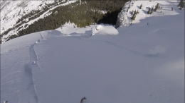
Strong southwest wind accompanied the end of the storm Friday, and 7-10” of new snow was drifted into 1-2’ thick wind slabs that are possible to trigger. Be cautious of steep, drifted slopes found near ridgelines, cliffs, and steep rollovers (photo). Keep a far distance from the edge of massive cornices, and avoid slopes directly below. Strong wind Friday formed widespread wind slabs that are possible to trigger and avalanche danger today is MODERATE.
Slopes that receive direct sun will have a surface crust this morning, which will minimize wet snow avalanches. If the crust softens or you see rollerballs and natural wet loose slides, be cautious of steep, sunny slopes.

Near Bozeman, Big Sky and West Yellowstone the snowpack is generally stable (video), but small and isolated avalanches can be triggered. Yesterday, skiers saw a cornice triggered avalanche in the Hourglass chute north of Bridger (photo, photo). Last Wednesday, a snowmobiler triggered and escaped an avalanche in the southern Madison Range. See video from Eric’s visit to the avalanche site and our accident report.
Huge cornices cling to the edge of ridgelines (photo, photo), and can break unexpectedly and farther back than anticipated. Keep a far distance from the edge of ridgelines and minimize time below. Also keep an eye out for small wind slabs that may be harmful in consequential terrain. On sunny slopes, wet loose avalanches can be triggered if the crust on the snow surface melts later in the day. The snowpack lacks widespread weak layers, but digging to assess structure and stability is recommended before riding avalanche terrain.
Avalanche danger today is LOW. There are still hazards to watch for during low danger, as highlighted in my recent video from Friday.
If you get out and have any avalanche or snowpack observations to share, drop a line via our website, email (mtavalanche@gmail.com), phone (406-587-6984), or Instagram (#gnfacobs).
Upcoming Avalanche Education and Events
LIVINGSTON
March 20, Beer for a Cause Night at Katabatic Brewing, 4-8p.m. A dollar from every pint will be donated to The Friends of the Avalanche Center.
In the last 2 weeks there have been 9 avalanche fatalities across the western U.S. This includes two people killed in a roof avalanche in Lake Tahoe. Our snowpack is currently more stable than other areas, but now is no time to let you guard down. See more info on recent accidents here: https://avalanche.org/avalanche-accidents/