Good Morning. This is Eric Knoff with spring snowpack and weather information on Friday, April 20th at 6:45 a.m. The Gallatin National Forest Avalanche Center has stopped issuing daily avalanche advisories for the season. This information will be updated Monday morning. This bulletin does not apply to operating ski areas. Bridger Bowl is closed for the season and backcountry conditions exist.
It’s hard to imagine, but the next few days will be sunny and warm. Highs today and through the weekend will reach the mid to upper 40’s F in the mountains and 50’s to 60’s in the valley. Lows will be in the 20s’ F. Winds will remain light to moderate out of west-southwest. There is little to no chance of precipitation the next few days. The next chance for rain and snow will be Monday and Tuesday.

For the first time all season, snotel sites across the advisory area lost SWE (snow water equivalent). This is a key indicator the snowpack is starting a well overdue transition to a warmer and wetter spring pack. This also means that free moving water is being introduced, which can create unstable conditions. Fortunately, temperatures dropped below freezing overnight, which helps slow the melting process and reduce rapid disintegration of the snowpack.
Today, stability will be fairly predictable. All but the highest north facing slopes will have a firm melt-freeze crust, which will create terrible riding conditions but good stability during the morning hours. As the day progresses, conditions will soften and stability will gradually decrease.
Slopes facing the south half of the compass will destabilize first. This will transition to east, west and eventually north facing slopes by the afternoon hours. Watch for pinwheels and small sluffs moving in steeper terrain. These are clues the snowpack is losing strength. If signs of instability are observed including soft-wet snow more than boot top deep, it’s time to move away from steep slopes or to shadier aspects.
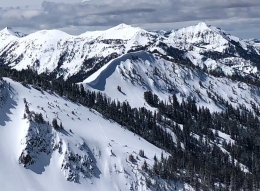
Cornices are also a significant hazard (photo). As temps warm above freezing, these overhanging masses of snow will become increasingly unstable. They can break farther back than you might expect and trigger large avalanches on the slopes below.
If you have not done so already, check out our spring avalanche advice below.
Share your observations with us on Instagram! #gnfacobs
Posting your snowpack and avalanche observations on Instagram (#gnfacobs) is a great way to share avalanche and weather information with us and everyone else this spring.
You can also drop a line via our website or email (mtavalanche@gmail.com) and we will share pertinent avalanche, weather and snowpack info as timely as possible.
Spring weather can be highly variable and create a mix of avalanche problems to watch out for. Snow conditions and stability can change drastically from day to day or hour to hour. A deep snowpack in the mountains will make avalanches possible for the next few months. Continue to assess the snowpack, weather, and terrain carefully and practice safe travel techniques for the remainder of the season.
NEW SNOW AND WIND LOADED SLOPES
Spring storms are notorious for depositing heavy amounts of snow in the mountains. Even with a deep and generally stable snowpack throughout the advisory area, heavy and rapid loads of new snow will decrease stability. The main problems to look out for are avalanches breaking within the new snow, wind slabs, and loose snow avalanches. The likelihood of triggering an avalanche spikes during and immediately after snow storms. New snow instabilities tend to stabilize quickly, but it’s a good idea to give new snow a day to adjust before hitting big terrain. New snow instabilities can be difficult to assess, and spring storms bond to old snow differently across aspects and elevations. Conservative terrain selection is essential during and immediately following storms. Wind loaded slopes and slopes steeper than 35 degrees should be avoided for 24-48 hours after new snow and wind.
New snow can quickly change from dry to wet on a spring day, and stability can decrease rapidly with above freezing temperatures or brief sunshine. New snow may bond well early in the morning, and then easily slide later. Wet loose slides are likely during the first above freezing temperatures or sunshine immediately after a storm. Anticipate changes in snow stability as you change terrain and over the course of the day. An early start is always an advantage. Be ready to change plans or move to safer terrain at the first signs of decreasing stability.
WET SNOW AVALANCHES
Spring and wet snow avalanches go hand-in-hand. Above freezing temperatures, rain, and/or intense sunshine cause the snow to become wet and weak, and make wet avalanches easy to trigger or release naturally. Conditions tend to become most unstable when temperatures stay above freezing for multiple days and nights in a row.
Avoid steep terrain, and be aware of potential for natural wet avalanches in steep terrain above you, if you see:
- Heavy rain,
- Above freezing temperatures for more than 24 hours,
- Natural wet avalanches,
- Roller balls or pin wheels indicating a moist or wet snow surface,
- Or if you sink to your boot top in wet snow.
In general, if the snow surface freezes solid overnight, the snowpack will be stable in the morning and stability will decrease through the day as snow warms up. The snow surface hardness, rate of warming, duration of sunshine, aspect and elevation determine how fast stability will decrease through the day. Be aware that sunny aspects may have a wet snow avalanche danger while shadier slopes still have a dry snow avalanche danger. Getting off of steep slopes should be considered when, or before, the above signs of instability are present. Wet snow avalanches, whether loose snow or slabs, can be powerful, destructive and very dangerous. Conservative terrain choices, starting early in the day, and careful observations can keep you safe.
CORNICES
Cornices along ridgelines are massive and can break under the weight of a person (photo). Prolonged above freezing temperatures and rain make them weaker and possible to break naturally. They can break off suddenly and farther back than one might expect. Cornice falls can also entrain large amounts of loose snow or trigger slab avalanches. Stay far back from the edge of ridgelines and minimize exposure to slopes directly below cornices. Regardless of whether a cornice triggers a slide or not, a falling cornice is dangerous to anyone in its path.
DISCLAIMER
It does not matter if new snow falls or not, avalanches will continue to occur until the existing snowpack is mostly gone. Always assess the slope you plan to ride with diligence and safety in mind. Do not let your guard down. Travel with a partner, carry rescue gear and only expose one person at a time in avalanche terrain.
Have a safe and enjoyable spring and summer!
Doug, Eric, and Alex
Info and Announcements
May 3-4th, Give Big online fundraising campaign! A 24-hour fund-raising campaign for the Friends of the Avalanche Center and other local nonprofits.
Hyalite Canyon road is closed to vehicles and reopens May 16th.
On April 12, 2018, Fisher Creek SNOTEL reached its most SWE on record for one season!!!
Sledders, mark your calendar for May 19, the 2nd Annual Sled Fest in Cooke City. It’s a fundraiser for the Friends of the Avalanche Center and there will be a DJ, raffle prizes and BBQ on the mountain.
May 3-4th, Give Big online fundraising campaign! A 24-hour fund-raising campaign for the Friends of the Avalanche Center and other local nonprofits.