Good morning. This is Doug Chabot with the Gallatin National Forest Avalanche Forecast issued on Wednesday, January 16th at 7:00 a.m. Today’s forecast is sponsored by Highline Partners and Mystery Ranch. This forecast does not apply to operating ski areas.
Last night 1-2” of snow fell in the southern mountains, Lionhead area and Cooke City. Temperatures are in the upper teens and winds are west to southwest at 10-15 mph with gusts of 30 mph. A moist south to southwest flow will bring increasing clouds, winds averaging 20 mph and daytime temperatures into the upper 20’s to low 30s. By morning I expect 1-2” of snow in the southern mountains and Cooke City, and more falling tomorrow over our entire forecast area.

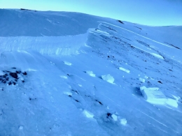
When the snowpack talks, we need to listen. On Sunday and Monday there were two triggered avalanches in the Taylor Fork area of the southern Madison Range. One was skier triggered (photo, details) and another was triggered by a snowmobiler on Skyline Ridge (photo, details). Both were 2-3 feet deep and ran on weak facets at the ground and either could have been deadly. It has been 8 days since the last snowfall, yet avalanches are still being triggered. The snow structure is bad. Traveling off a beaten path means you’ll wallow in the unsupportable facets. I rode into Taylor Fork yesterday and no matter how many snowpits I dig this season, I’m always surprised at how weak the snow is (video). Taylor Fork, Cabin Creek, Lionhead, Bacon Rind…they are all similarly shallow and weak. If Mother Nature talks (collapsing, cracking, avalanches), you should be a good boy and girl and listen to her advice to stay out of avalanche terrain. For today, since triggering avalanches is still possible, the avalanche danger is rated MODERATE on all slopes.

Triggering an avalanche in the northern mountains and around Cooke City is unlikely, but not impossible. It’s been a depressingly dry January (chart) and without a new snow load it becomes more difficult to trigger slides. However, it would be imprudent to think all avalanche terrain is safe. A sledder triggered a small slide in Buck Ridge on Friday which Ian and Alex investigated (photo, video), and Eric had collapsing and cracking on Saturday north of Big Sky (video). Sugary facets at the ground make for a poor and weak snow structure. These isolated signs of instability illustrate the lingering potential to trigger a slide. Anytime we find a dense slab of snow capping soft, airy facets, we take notice. A crack or collapse should be enough to turn us around. For today, the avalanche danger is rated LOW. It’s not a “turn your brain off” low, but a “pay attention” low.
If you get out and have any avalanche or snowpack observations to share, contact us via our website, email (mtavalanche@gmail.com), phone (406-587-6984), or Instagram (#gnfacobs).
Upcoming Avalanche Education and Events
Our education calendar is full of awareness lectures and field courses. Check it out: Events and Education Calendar.
BOZEMAN
January 16, 17 and 19 or 20, Intro to Avalanches w/ Field Day, Info and Register Here.
January 23, 24 and 26, Advanced Avalanche Workshop w/ Field Day, Info and Register Here.
February 2, King and Queen of the Ridge at Bridger Bowl (fundraiser). Register with Bridger to hike in the event, and create a pledge page to raise funds with your Ridge laps.
BIG SKY
January 22, Pint Night at Beehive Brewery, 4-8 p.m. A fundraiser for the Darren Johnson Avalanche Education Memorial Fund.
WEST YELLOWSTONE
January 26, 1-hr Avalanche Awareness for Snowmobilers, 7-8 p.m. Holiday Inn West Yellowstone.
DILLON
January 22, 1-hr Avalanche Awareness, 6:30-7:30 p.m. U.M. Western Library.
BILLINGS
January 22, 1-hr Avalanche Awareness, 6-7 p.m. The Base Camp, Billings.
COOKE CITY
Every Friday and Saturday, Rescue Training and Snowpack Update. Friday 6:30-7:30 p.m. at the Soda Butte Lodge. Saturday anytime between 10-2 @ Round Lake.
The government shutdown and its effects on USFS avalanche centers is highlighted in this article in Powder Magazine.