Good morning. This is Eric Knoff with the Gallatin National Forest Avalanche Forecast issued on Friday, January 18th at 7:00 a.m. Today’s forecast is sponsored by Knoff Group Real Estate and PH. D. Skis. This forecast does not apply to operating ski areas.
Over the past 24 hours the mountains near West Yellowstone and Cooke City picked up 5-6” of new snow while the mountains near Bozeman and Big Sky received 3-5”. At 5 a.m. it’s still snowing in the Bridger Range, but dry elsewhere. Temps range from the teens to low 20’s F and winds are blowing 10-20 mph out of the west-northwest. Ridgetop gusts near Bozeman and Big Sky are pushing 30 mph. Today, snow tapers off by mid-morning and skies will be partly cloudy by this afternoon. Temps warm into the mid to high 20’s F and winds will blow 10-20 mph shifting to the west-southwest. A weak storm will brush by the southern mountains tonight delivering 1-2” of snow to West Yellowstone and Cooke City.

Over the past two days, the Lionhead area near West Yellowstone picked up to 7-8” of snow totaling .7” of SWE. The southern Madison and Gallatin Ranges were less favored, but still received 5-6” of snow totaling .5” of SWE. The snowpack in the southern ranges resembles a house of cards, which will be pushed close to its breaking point today (video).
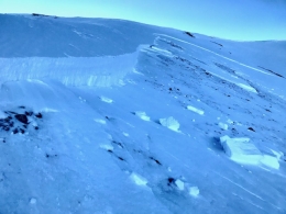
A layer of surface hoar buried up to a foot deep and/or facets near the ground are both capable of producing avalanches (photo). A large slide triggered by skiers in the southern Madison Range on Monday is a good example of what’s possible today. This slide occurred on a wind loaded slope, broke 2-3’ deep, 400’ wide and failed on facets near the ground (photo, details). Today, all steep slopes, wind loaded or not are capable of producing avalanches. The best defense against a persistent weak layer problem is to avoid riding on or underneath slopes steeper than 35 degrees (photo).
Today, dangerous avalanche conditions exist and the avalanche danger is rated CONSIDERABLE.
The mountains near Cooke City squeezed out 6-7” of snow totaling .7” of SWE over the past two days. Normally, this would be a small to medium sized storm for Cooke City, but this year is different. Below average snowfall has left the snowpack shallow and weak on many slopes. The new snow will be adding stress to weak layers buried mid pack and near the ground. Slopes that have wind drifted snow and areas where the snowpack is less than 3’ deep will be the most unstable. Due to the high variability of the snowpack around Cooke City, it’s necessary to evaluate each slope carefully before committing to avalanche terrain.
Signs of instability such as cracking and collapsing or recent avalanches are Mother Nature’s bull horn alerting you to unstable conditions. Today, a snowpack under stress makes human triggered avalanches likely and the avalanche danger is rated CONSIDERABLE.

Someone burned a good pair of skis last night and got Ullr’s attention. Since midnight, the Bridger Range received 4-5” of new snow totaling .5” of SWE. The mountains around Big Sky picked up 4-6” since yesterday morning. New snow combined with west-northwest winds will create a touchy batch of wind slabs up to a foot thick. Fresh wind slabs will be most prevalent on upper elevation slopes loaded by west-northwest winds. Most slides will stay confined to the new snow, but there is the potential for slides to step down to weak layers buried deeper in the pack. Watch out for this problem on slopes with a weak and shallow snowpack (video, video, photo).
Skiers or riders may also trigger dry loose avalanches or sluffs on steep slopes. This problem won’t create a significant hazard, but will be something to watch out for in steep terrain.
Today, human triggered avalanche are possible and the avalanche danger is rated MODERATE.
Upcoming Avalanche Education and Events
Our education calendar is full of awareness lectures and field courses. Check it out: Events and Education Calendar.
BOZEMAN
January 23, 24 and 26, Advanced Avalanche Workshop w/ Field Day, Info and Register Here.
February 2, King and Queen of the Ridge at Bridger Bowl (fundraiser). Register with Bridger to hike in the event, and create a pledge page to raise funds with your Ridge laps.
BIG SKY
January 22, Pint Night at Beehive Brewery, 4-8 p.m. A fundraiser for the Darren Johnson Avalanche Education Memorial Fund.
WEST YELLOWSTONE
January 26, 1-hr Avalanche Awareness for Snowmobilers, 7-8 p.m. Holiday Inn West Yellowstone.
DILLON
January 22, 1-hr Avalanche Awareness, 6:30-7:30 p.m. U.M. Western Library.
BILLINGS
January 22, 1-hr Avalanche Awareness, 6-7 p.m. The Base Camp, Billings.
COOKE CITY
Every Friday and Saturday, Rescue Training and Snowpack Update. Friday 6:30-7:30 p.m. at the Soda Butte Lodge. Saturday anytime between 10-2 @ Round Lake.
The government shutdown and its effects on USFS avalanche centers is highlighted in this article in Powder Magazine.