Good morning. This is Alex Marienthal with the Gallatin National Forest Avalanche Forecast issued on Monday, February 4th at 7:00 a.m. Today’s forecast is sponsored by Community Food Co-op and Swiss Fit Montana. This forecast does not apply to operating ski areas.
AVALANCHE WARNING
We issued a Backcountry Avalanche Warning for the Lionhead area near West Yellowstone, the Centennial Range, and the southern Madison and southern Gallatin Ranges. Heavy snow and wind are loading a weak snowpack. Natural and human triggered avalanches are likely. Avalanche terrain and avalanche runout zones should be avoided. Very dangerous avalanche conditions exist and avalanche danger is HIGH on all slopes. This warning will expire or be updated by 6:00 a.m. on February 5, 2019.
Since yesterday morning the mountains received 10-12” of dense new snow near West Yellowstone and Cooke City, 8-10” near Big Sky, and 3-5” in Hyalite and the Bridger Range. Near Bozeman, an inversion has temperatures near and below zero F at 7,500’ and below, and low 20s F above 8,000’. Elsewhere temperatures are teens to low 20s F. Wind is south-southwest at 15-25 mph this morning with gusts of 40-50 mph yesterday. Today temperatures will remain cold and inverted near Bozeman, and teens to 20s F elsewhere. Wind will be 15-25 mph out of the south-southwest. Snow continues this morning in the southern mountains and resumes tonight in the northern mountains. By morning expect 5-8” near West Yellowstone and Cooke City, and 3-5” near Big Sky and Bozeman.

Avalanche Warning
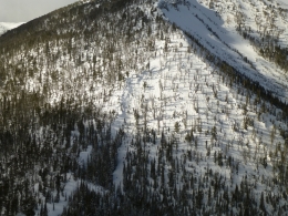
Over the last 24 hours more than a foot of heavy snow (1.2” of snow water equivalent) fell near West Yellowstone and the southern Madison and Gallatin Ranges, and snow continues this morning. Moderate southwest winds drifted this snow into thick slabs on an unstable snowpack. Ian skied at Bacon Rind in the southern Madison Range yesterday and found a layer of weak surface hoar below 6” of new snow. He got unstable test results on this weak layer and on a layer of sugary snow buried 2-3’ deep (video). An additional 10-12” of snow since yesterday makes large natural and human triggered avalanches likely to break on these weak layers (photo, photo). Very dangerous avalanche conditions exist and avalanche danger is HIGH. Avoid travel on and underneath steep slopes.

Since yesterday the mountains near Cooke City and Big Sky have 8-10” of snow equal to 0.8 to 1.0” of SWE. These areas are a long distance apart, but today have similar avalanche conditions and travel advice. Moderate to strong southwest wind formed 1-2’ thick drifts that are easy to trigger. Natural avalanches are possible today where southwest wind continues to form heavy, thick drifts. On non-wind loaded slopes, avalanches of new snow and loose snow avalanches are easy to trigger. Avalanches could break 2-3’ deep and propagate wide on layers of weak, sugary facets. I was in Cooke City four days ago and had a large collapse (video, video) where the snowpack was less than 3-4 feet deep. Carefully assess the snowpack and effects of the wind today. Avoiding avalanche terrain is advised while the snowpack adjusts to the weight of new snow. Avalanche danger is CONSIDERABLE.

Yesterday the Bridger Range and Hyalite got 3-5” of snow equal to 0.3-0.5” of SWE. This is not a lot of weight added to buried weak layers, but enough to keep them on edge. It is possible to trigger avalanches on 2-3’ deep on sugary facets where the snowpack is shallow (less than 3-4’). Last week’s observations from Mt. Ellis (video, avalanche incident) and large avalanches on Bridger Peak and the West side of the Bridgers show where this weak snowpack exists. Yesterday I went to the northern Bridger Range and found small fresh drifts of snow were easy to trigger (video). These drifts are possible to trigger today, and could be hazardous in high consequence terrain. Today, buried weak layers and wind drifted snow make avalanches possible and avalanche danger is MODERATE.
If you get out and have any avalanche or snowpack observations to share, contact us via our website, email (mtavalanche@gmail.com), phone (406-587-6984), or Instagram (#gnfacobs).
King and Queen of the Ridge
A huge thank you to all who hiked and raised funds for the Friends of the Avalanche Center. We greatly appreciate this amazing support from our community. King and Queen of the Ridge (Overall Results). The top fund raising teams and individuals were:
#1 Fundraising Team (also top Family Team) -- Flamingo Flyers, $1814
#2 Fundraising Team -- Rocky Hoarer Powder Snow, $1564
#3 Fundraising Team -- Bridger Brigade, $1300
#4 Fundraising Team -- Strange Cattle of MAP Brewing, $1252
#1 Fundraising Individual -- Nick English (of Flamingo Flyers), $1323
#2 Fundraising Individual -- Grant Petersen (of Rocky Hoarer), $1185
#3 Fundraising Individual -- Axel Peterson (of Bridger Brigade), $650
#4 Fundraising Individual -- Niles Fetter, $611
Upcoming Avalanche Education and Events
Our education calendar is full of awareness lectures and field courses. Check it out: Events and Education Calendar.
BOZEMAN
February 6, 1-hr Women’s Avalanche Awareness, 6-7p.m. at REI Bozeman.
February 8 and 9, Companion Rescue Clinic, 6-8 p.m. Friday at REI, 10-4 Saturday in the field. More Info and Register.
February 22 and 23, Women’s Companion Rescue Clinic, 6-8 p.m. Friday at REI, 10-4 Saturday in the field. More Info and Register.
WEST YELLOWSTONE
February 9, 16 and 23, 1-hr Avalanche Awareness for Snowmobilers, 7-8 p.m. Holiday Inn West Yellowstone.
HELENA
February 13, 1-hr Avalanche Awareness, 6-7 p.m. at Carroll College.
COOKE CITY
Every Friday and Saturday, Rescue Training and Snowpack Update. Friday 6:30-7:30 p.m. at the Soda Butte Lodge. Saturday anytime between 10-2 @ Round Lake.