Good morning. This is Ian Hoyer with the Gallatin National Forest Avalanche Forecast issued on Tuesday, February 12th at 7:10 a.m. Today’s forecast is sponsored by Mystery Ranch and World Boards. This forecast does not apply to operating ski areas.
Overnight 3-4” of dense snow fell in the Lionhead Range and near Cooke City, with no new snow elsewhere. Mountain temperatures are high single digits F to mid-teens. Winds are southwest to northwest at 15-30 mph with gusts into the 40s mph. Temperatures will rise into the teens and twenties with strong winds out of the south and southwest. Snow tonight will bring 3-5” around West Yellowstone and Cooke City, less near Bozeman and Big Sky.

Touchy slabs of wind drifted snow sit over a weak snowpack in the southern ranges. Snow water equivalent (SWE) totals range from 1” to 1.4” since Friday. While most of that snow fell over the weekend, southwest winds increased yesterday accelerating transport onto wind-loaded slopes. Fresh drifts are 2-3’ thick and can be triggered by the weight of a single skier or rider.
Avalanches can also break on weak layers buried 2-4’ deep (deeper on wind-loaded slopes). There were a number of avalanches on these weak layers in the middle of last week (photo, video, details). Some of these slides broke near the ground, taking out the entire season’s snowpack. Avalanches breaking this deep can produce a huge amount of debris, even on relatively small slopes. A slide on Saturday in the Centennial Range that only ran 50’ vertical feet (link to video, photo) fully buried a rider and his snowmobile (photo), reinforcing the dangers of small slopes. You can trigger these slides from flat terrain beneath steeper slopes. Stay well out from under steep slopes, especially where there is a gully, trees, or other terrain trap below. Triggering an avalanche is likely and the avalanche danger is CONSIDERABLE.
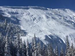
Four inches of new snow fell near Cooke City overnight, accompanied by strong southwest winds. The new snow is dense, equaling 0.6” of SWE. While riding near Cooke City yesterday Doug found hard, thin drifts of wind drifted snow were cracking beneath him. These drifts will be both thicker and more reactive today. You can easily trigger an avalanche on steep, wind-loaded slopes. Steer clear of slopes with thick drifts of windblown snow to avoid this possibility. The snowpack is generally getting both deeper and stronger (photo), but there is still weak snow on some slopes that is capable of producing large avalanches. There are weak layers both mid-pack and on slopes with a shallow snowpack, weak snow near the ground. Saturday’s snowmobile triggered slide on Mt. Abundance appears to have broken on that weak snow near the ground (details and photos). Before riding into steep terrain, dig down to make sure you aren’t dealing with these reactive weak layers.
On wind loaded slopes, triggering an avalanche is likely and the avalanche danger is CONSIDERABLE. On non-windloaded slopes, the avalanche danger is MODERATE.

Despite no new snow this morning, there is soft snow available for the strong winds to transport. You can trigger an avalanche today in wind drifts 1-2’ thick. Look for these drifts below corniced ridgelines, on gully walls, and downwind of tree islands. If you see cracking around you or feel hard, punchy snow, stick to lower angled slopes. Be particularly cautious on slopes where a small avalanche would have big consequences (above trees, rocks, cliffs, etc).
While triggering an avalanche on deeper weak layers has become unlikely, we can’t completely forget about them. Dig down 3-4 feet to look for these weak layers and assess their stability before committing to steep slopes. On wind loaded slopes, the avalanche danger is MODERATE. On non-windloaded slopes, the avalanche danger is LOW.
If you get out and have any avalanche or snowpack observations to share, contact us via our website, email (mtavalanche@gmail.com), phone (406-587-6984), or Instagram (#gnfacobs).
Story Mill Beacon Park
Stop by the public beacon park at the Bozeman Parks North Recreation Center at Story Mill on Rouse St. It is operational from 8:30 a.m. to 5:00 p.m. 7 days a week. Here’s a fun video outlining how to use the park: https://www.facebook.com/friendsgnfac/videos/279522799401278/
Upcoming Avalanche Education and Events
Our education calendar is full of awareness lectures and field courses. Check it out: Events and Education Calendar.
BOZEMAN
February 22 and 23, Women’s Companion Rescue Clinic, 6-8 p.m. Friday at REI, 10-4 Saturday in the field. More Info and Register.
WEST YELLOWSTONE
February 16 and 23, 1-hr Avalanche Awareness for Snowmobilers, 7-8 p.m. Holiday Inn West Yellowstone.
HELENA
February 13, 1-hr Avalanche Awareness, 6-7 p.m. at Carroll College.
COOKE CITY
Every Friday and Saturday, Rescue Training and Snowpack Update. Friday 6:30-7:30 p.m. at the Soda Butte Lodge. Saturday anytime between 10-2 @ Round Lake.
This video interviewing one of the party members involved in Saturday’s fatal avalanche in Utah is a sobering account of a tragic accident.