Good morning. This is Doug Chabot with the Gallatin National Forest Avalanche Forecast issued on Valentine’s Day, Thursday, February 14th at 7:00 a.m. Today’s forecast is sponsored by our sweeties, Allyson, Nina, Marcie and Leila. This forecast does not apply to operating ski areas.
AVALANCHE WARNING
The Gallatin National Forest Avalanche Center is issuing a Backcountry Avalanche Warning for the Lionhead area near West Yellowstone, the Centennial Range, the southern Madison and southern Gallatin Ranges. Heavy snow and wind are creating unstable conditions. Natural and human triggered avalanches are likely. Avalanche terrain and avalanche runout zones should be avoided. Very dangerous avalanche conditions exist and the avalanche danger is rated HIGH on all slopes.
The mountains around West Yellowstone received an estimated 16+” of snow and Cooke City received a foot. The mountains around Bozeman and Big Sky picked up 2-3”. Snowfall stopped at midnight and west to southwest winds subsided to 15 mph with gusts of 30-40 mph. Temperatures will remain in the teens today. Another snowstorm hits this afternoon and will drop 2-4” in the northern areas and close to 8” in the southern ranges by morning. Winds will continue to blow 15-30 mph out of the west to southwest.

Avalanche Warning
The Lionhead area, southern Madison and southern Gallatin Ranges, got slammed with snow and wind. There is an AVALANCHE WARNING in these mountains. 1-1.5 feet of new snow is a conservative estimate (1-1.3” of snow water equivalent) and more is expected today. There will be avalanches in the new snow, wind-loaded or not. Avalanches may break near the ground where weak, sugary facets are unable to support this load. Yesterday, Eric was in Cabin Creek in the middle of the storm and noted the avalanche danger was rising quickly (video). It snowed 1” an hour for 12 hours, a fast rate which adds to the instability. The avalanche warning is not to be trifled with. People die in these conditions. Avalanches will be wide and deep. Stay away from runout zones. For today, the avalanche danger is rated HIGH on all slopes.

Over a foot of snow (1” SWE) fell outside Cooke City yesterday. Westerly winds are strong and gusting into the 40s. More snow is expected this afternoon and tonight. New snow and wind drifted snow has elevated the avalanche danger. There will be a few natural slides on wind-loaded slopes but most importantly, you are likely to trigger avalanches in the new and windblown snow. Today is a day to notch back ambitions and stay clear of avalanche terrain. Avalanches may break deeper on mid-pack layers or on facets near the ground in shallow areas. There’s no telling where it might break, and really, it’s moot. People die in both small and big avalanches and today you could trigger both. The avalanche danger is rated CONSIDERABLE on all slopes.

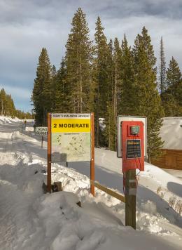
The mountains around Bozeman and Big Sky got 2-3” of snow last night with westerly winds blowing 15-30 mph. Yesterday, I skied to Mt. Ellis which has some of the weakest snow in the northern ranges. My partners and I wanted to investigate how it would handle more snowfall. We dug two snowpits and were surprised at the improved stability from 2 weeks ago (video). Our tests were not propagating and last night’s snow will not makes things worse on non-wind loaded slopes. However, strong ridgetop winds created 6-12” thick wind slabs that could be triggered. Shooting cracks in wind drifts are a sign to stay off the slope. For today, the avalanche danger is rated MODERATE on slopes that are wind-loaded and LOW elsewhere.
Upcoming Avalanche Education and Events
Our education calendar is full of awareness lectures and field courses. Check it out: Events and Education Calendar.
BOZEMAN
February 22 and 23, Women’s Companion Rescue Clinic, 6-8 p.m. Friday at REI, 10-4 Saturday in the field. More Info and Register.
WEST YELLOWSTONE
February 16 and 23, 1-hr Avalanche Awareness for Snowmobilers, 7-8 p.m. Holiday Inn West Yellowstone.
COOKE CITY
Every Friday and Saturday, Rescue Training and Snowpack Update. Friday 6:30-7:30 p.m. at the Soda Butte Lodge. Saturday anytime between 10-2 @ Round Lake.
The Friends of the Avalanche Center and Montana State Parks installed an avalanche danger sign outside Cooke City. It sits next to the beacon checker and will be seen by riders and skiers as they head out of town.