Good morning. This is Alex Marienthal with the Gallatin National Forest Avalanche Forecast issued on Sunday, February 24th at 7:00 a.m. Today’s forecast is sponsored by Grizzly Outfitters and The Friends of the Avalanche Center. This forecast does not apply to operating ski areas.
At 4 a.m. there is 6” of low density new snow at Lionhead and in the Bridger Range, and 2-4” elsewhere. Temperatures are single digits F this morning and will reach teens F today. Wind is west-southwest at 10-15 mph with gusts to 25 mph, and northwest near Cooke City. Today wind will be south-southwest at 10-20 mph with gusts of 30-40 mph this afternoon, and will shift east in the Bridger Range. Snow showers are expected through Tuesday with heavy snowfall possible this afternoon and tonight. By tomorrow morning 8-12” of new snow is likely.

Near West Yellowstone and in the southern Madison and Gallatin Ranges weak layers of sugary snow at the base of the snowpack have had minimal stress from new snow over the past week (weather log), and they will hardly notice today’s lightweight snow. Yesterday Eric and I toured near Hebgen Lake outside of West Yellowstone. We found that a lot of force is required to break the weak snow at the foundation of the snowpack, and avalanches on this layer are difficult to trigger (video). However, these avalanches will be large and there are no warning signs such as collapses in flat terrain or reactive test slopes (video, details and photos). Tracks on a slope do not indicate stability. Due to difficult stability assessment, the best strategy is to avoid steep slopes, especially those beneath cornices or in steep rocky terrain.
This morning the mountains have 3-6” of new snow equal to 0.3-0.5” of snow water equivalent (SWE). Moderate southwest wind drifted this snow into small soft slabs that can be triggered by a skier or rider. These slabs are most hazardous if they catch you in higher consequence terrain where they could push you into trees or over cliffs. Today, buried weak layers and new snow make avalanches possible and avalanche danger is MODERATE. With more snow later today expect slabs of new and wind-drifted snow to grow, and overall stability to decrease.
In the mountains near Bozeman, Big Sky and Cooke City recent moderate wind formed drifts 1-2’ thick that are possible to trigger (photo). Blowing and drifting snow or cracking of the snow surface are signs to avoid steep, wind-loaded terrain. With more snow and wind today expect drifts to grow and become more unstable. In the Bridger Range east wind will form drifts in unusual locations.
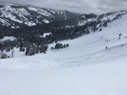
Avalanches breaking deeper than new and wind-drifted snow are unlikely. On specific slopes there is an isolated chance you could trigger a deep avalanche similar to a couple that were triggered last week near Big Sky (photo, photo, video). The most suspect slopes for this problem are heavily wind loaded, or where the snowpack is relatively shallow (less than 3-5 feet). Today, avalanche danger is MODERATE on wind loaded slopes and LOW on non-wind loaded slopes. This afternoon danger will increase if snowfall is heavy.
If you get out and have any avalanche or snowpack observations to share, contact us via our website, email (mtavalanche@gmail.com), phone (406-587-6984), or Instagram (#gnfacobs).
Upcoming Avalanche Education and Events
Our education calendar is full of awareness lectures and field courses. Check it out: Events and Education Calendar.
BOZEMAN
March 1, 2 and 3, Bozeman Split Fest, More info at www.bozemansplitfest.com.
March 6, 1-hr Avalanche Awareness, 6-7 p.m. at REI Bozeman.
ENNIS
February 28 and March 3, Intro to Avalanches w/ Field Day, More Info and Register Here.
COOKE CITY
Every Friday and Saturday, Rescue Training and Snowpack Update. Friday 6:30-7:30 p.m. at the Soda Butte Lodge. Saturday anytime between 10-2 @ Round Lake.
On Tuesday, a backcountry skier ascending a trail near Telluride, Colorado was buried and killed by an avalanche triggered by a rider descending above him. Preliminary details and photographs here.