Good morning. This is Eric Knoff with the Gallatin National Forest Avalanche Forecast issued on Saturday, March 2nd at 7:00 a.m. Today’s forecast is sponsored by Mystery Ranch and Bridger Bowl. This forecast does not apply to operating ski areas.
Since yesterday morning the mountains picked up 1-3” of new snow. Additional accumulation is unlikely today as cold-dry air moves over the region. At 5 a.m. temperatures are 10-15 below zero F in the Bridger Range and single digits above zero F elsewhere. Winds are blowing 10-30 mph out of the west-northwest. Today, highs will barely warm into the teens F and winds will remain light to moderate out of the west-northwest. No real snow accumulation is expected over the next 24 hours.

A break in the weather yesterday allowed the avalanche warning to expire and gave the snowpack a well needed sigh of relief. After being inundated by multiple feet of snow over the past week, the snowpack is slowly adjusting and stability is gradually improving.
Yesterday, Alex and I rode into Taylor Fork in the southern Madison Range and we were pleasantly surprised by the lack of recent avalanche activity. However, the snowpack remains under a significant amount stress and human triggered avalanches remain likely.
Slides breaking 1-3’ deep in new and wind-blown snow is the main concern. Yesterday, a skier outside of Cooke City observed numerous natural avalanches that failed in the new snow. Today, similar slides are likely, mainly on slopes with wind drifted snow (photo, photo). A less probable but more dangerous problem are slides breaking on weak layers buried deep in the pack (video). Slides failing in the new snow could step down and trigger on of these monsters, or a skier or rider could find a specific trigger point that could release the entire slope.
Today, careful snowpack evaluation and conservative decision making are essential. Dangerous avalanche conditions exist and the avalanche danger is rated CONSIDERABLE.
Wind loaded slopes are the main concern in the mountains around Bozeman and Big Sky. Wind drifts will be largest and most widespread on upper elevation slopes loaded by west-southwest winds. Be especially aware of this problem on steep slopes below ridgelines, on the sides of cross loaded gullies, and below exposed cliff bands (photo). Consider the consequences of triggering a slide before committing to avalanche terrain. Even small slides can be deadly if they carry you over rocks or push you into trees. The avalanche fatality in the Bridger Range on Tuesday is a reminder of how specific terrain can increase the consequences of being caught in a slide. Read the full accident report here.
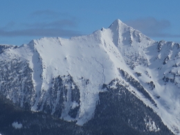
Although most slides will stay confined to the upper 1-2’ of the snowpack, deep slab avalanches remain a possibility. A large slide on Wilson Peak near Big Ski is a reminder that persistent weak layers near the ground still exist and can fail under the right conditions (photo). These types of slides are becoming less likely, but can’t be entirely ruled out.
Today, human triggered avalanches are likely on wind loaded slopes which have a CONSIDERABLE avalanche danger. Non-wind loaded slopes have a MODERATE avalanche danger.
Upcoming Avalanche Education and Events
Our education calendar is full of awareness lectures and field courses. Check it out: Events and Education Calendar.
BOZEMAN
Today and tomorrow, Bozeman Split Fest, More info at www.bozemansplitfest.com.
March 6, 1-hr Avalanche Awareness, 6-7 p.m. at REI Bozeman.
COOKE CITY
Every Friday and Saturday, Rescue Training and Snowpack Update. Friday 6:30-7:30 p.m. at the Soda Butte Lodge. Saturday anytime between 10-2 @ Round Lake.
The accident report for the avalanche fatality in the Bridger Range on February 26th is complete. You can view the report here.