Good morning and happy St. Patrick’s Day. This is Alex Marienthal with the Gallatin National Forest Avalanche Forecast issued on Sunday, March 17th at 6:45 a.m. Today's forecast is sponsored by Mystery Ranch and Ph.D. Skis. This forecast does not apply to operating ski areas.
This morning the mountains have no new snow. Temperatures are teens to low 20s F and wind is westerly at 5-15 mph. Today temperatures will reach mid to upper 30s F under mostly sunny skies. Wind will be west-northwest at 5-15 mph. For the next week expect clear skies with daily high temperatures steadily rising through the week

All Regions
Small wet loose avalanches are possible on sunny slopes this afternoon. Otherwise, the snowpack is generally stable and avalanches are unlikely. Slopes that receive direct sun have a thick frozen crust which makes them stable this morning. Today, warm temperatures and sun will melt this crust and the snow surface will become unstable. Anticipate decreasing stability on sunny slopes. Move to shadier slopes or lower angle terrain if the snow surface becomes moist, or if you see roller balls or natural point release slides. Today wet loose slides will not be large enough to bury a person, but are dangerous if they knock you down or carry you through trees or over rocks.
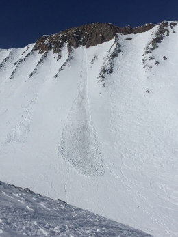
The last couple days temperatures reached the high 30s F, yet snow remained dry on shady slopes and there were generally few wet loose slides (photos). Similar weather today will create similar conditions. On Friday we went to Mt. Blackmore and yesterday to the northern Bridger Range. In both places we found a generally stable snowpack aside from small loose snow avalanches (photo, photo). Near Fairy Lake we saw old wind slab crowns that show the type of terrain where there is an isolated chance to trigger one of these, and we saw small slides in terrain with high consequences (video). Without a recent loading event, avalanches failing deeper in the snowpack are unlikely (video).
Today the snowpack is generally stable aside from small loose snow avalanches, and avalanche danger is rated LOW. If you travel into steep terrain, remain cautious and carefully assess the snowpack and consequences of being caught in a slide.
If you get out and have any avalanche or snowpack observations to share, contact us via our website, email (mtavalanche@gmail.com), phone (406-587-6984), or Instagram (#gnfacobs).
Upcoming Avalanche Education and Events
Spring is here and wet snow avalanches are becoming a daily concern. Anticipate decreasing stability while forming a travel plan. This article from Backcountry Magazine highlights some things look for that indicate when it is time to turn around.