This is Dave Zinn with pre-season avalanche, weather and event information for the Gallatin National Forest Avalanche Center on Thursday, November 14th. This update is sponsored by Knoff Group Real Estate and Alpine Orthopedics.
*Note: Bridger Bowl Ski Area is closed and there is no avalanche control or ski patrol services. Backcountry conditions exist. Workers are setting up for the season and making snow. Please stay clear of work areas, snow guns, chair lifts, and other equipment.
Tuesday night, the mountains received 2” of snow with 5” in Hyalite. There has been no precipitation since then, mountain temperatures have been in the 20s and 30s F with winds 15-30 mph from the west.
Warm, dry weather will continue until Friday night, temperatures will be in the 30s and 40s F with winds 10-20 mph from the west to southwest. Friday night, the mountains will get a trace to 2” of snow with lingering flurries around Cooke City. Our next chance for snow will come early next week.
We will update our Weather Log and Regional Conditions every morning with snowfall totals, and our Avalanche Activity list if we get a report.

All Regions
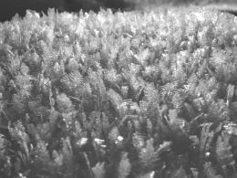
Mountain weather fluctuated dramatically over the last week and added interesting layers, but the snowpack remains stable without the additional weight of new snow (photo, profile). We are keeping wet snow, surface hoar, and new snow in our minds for the weekend. Daytime temperatures in the upper 30s and 40s F could lead to isolated wet snow avalanches pushing you into hazardous terrain. Move to cooler slopes if you start sinking into sloppy, wet snow on your tour. In Hyalite Canyon, a skier observed feathery surface hoar crystals before they were likely buried by Tuesday night’s snow (photo). Look for an obvious stripe in your snowpit about 5” under the surface and use a stability test to assess this weak layer. On Tuesday, climbers outside our advisory area in the Absaroka Range had a scare when they triggered a wind-loaded slope while approaching their route (avalanche report). Wind slabs that formed earlier this week have stabilized, but Friday night’s snow and wind will add sensitive drifts of snow into the mix.
People across Southwest Montana are getting ready for winter. As you think about getting your snow tires on, tuning skis, boards, and sleds, add your avalanche gear to your pre-season checklist as Ian show us in his video so you will be ready to go when the next storm hits (video).
If you have avalanche, snowpack, or weather observations to share, please submit them via our website, email (mtavalanche@gmail.com), phone (406-587-6984), or Instagram (#gnfacobs).
Upcoming Avalanche Education and Events
Our education calendar is full of awareness lectures and field courses. Check it out and plan to attend one or two: Events and Education Calendar.
BOZEMAN
Tonight! 14 November, 1-hr Avalanche Awareness, 6-7pm @ South Hedges Hall, MSU.
Tonight! 14 November, 1-hr Avalanche Awareness, 6-7pm @ Uphill Pursuits.
20 November, 1-hr Avalanche Awareness, 6-7pm @ The Mountain Project.
4 & 5 December, Introduction to Avalanche w/ Field Course, Evenings of December 4 & 5 plus one field day either December 7, 8 or 14. Snowmobile specific field day offered December 14. More info and Register Here.
11 December, 1-hr Avalanche Awareness, 6-7pm @ REI
12 December, 1-hr Avalanche Awareness and Beacon Practice, 6-8pm @ Story Mill Community Center
HELENA
23 November, Helena Snowdrifters, Avalanche Awareness and Partner Rescue Training, 9am-3pm at the Mako Building in Helena.
BILLINGS
19 November, 1-hr Avalanche Awareness, 6-7pm @ The Base Camp in Billings.
BUTTE
19 November, 1-hr Snowmobile Avalanche Awareness, 6-7pm @ Redline Sports in Butte.
Our education calendar is full of awareness lectures and field courses. Check it out and plan to attend one or two: Events and Education Calendar.