This is Dave Zinn with the avalanche forecast for the Gallatin National Forest Avalanche Center on Monday, December 2nd at 7:30 a.m. Today’s forecast is sponsored by Highline Partners and the Yellowstone Club Community Foundation. This forecast does not apply to operating ski areas.
*Note: Bridger Bowl Ski Area is closed and there is no avalanche control or ski patrol services. Backcountry conditions exist. Workers are setting up for the season and making snow. Please stay clear of work areas, snow guns, chair lifts and other equipment.
Last night the northern ranges received another 1-2” of snow and the southern ranges got 2-4”. Winds were 15-25 mph from the west to southwest with temperatures in the upper teens and 20s F. Today, the mountains around West Yellowstone and Cooke City will receive 2-4” and the northern ranges will get a trace to 1” before the snow tapers off this afternoon. Temperatures will be in the 20s F with winds from the west to southwest at 15-30 mph.

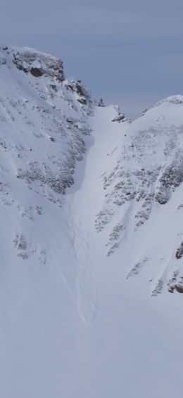
Last night an additional 2-4” of snow fell on top of the 12-16” from the previous five days. The weight of the 1.7” of snow water equivalent (SWE) is keeping this weak snowpack on edge. Doug and I rode and skied into the Lionhead Range yesterday to see how the sugary foundation is supporting the new load. We heard the snowpack collapse with a “whumph” sound and had unstable results in our snowpit (video). This is consistent with what other skiers in the area reported on Saturday (photo). Several inches of snow last night along and wind will keep the avalanche hazard elevated today. Over the next few days, as the storm ends and the snowpack adjusts to the new weight, it will become harder to trigger avalanches, but the weak layer near the ground will be with us going forward and cause problems with each snowstorm.
Today human triggered avalanches are likely on steep and wind loaded slopes. These avalanches could be large and it will still be possible to trigger these avalanches from the bottom of slopes. The avalanche danger is rated CONSIDERABLE. Avoid travel on and underneath avalanche terrain and pay special attention to wind loaded areas.

The foundation of the snowpack around Bozeman, Big Sky, and Cooke City is generally stable and was able to handle the 6-12” of snow during the last week. The avalanche concern today is fresh drifts of snow. Skiers and climbers at Bridger Bowl, Beehive, and around Hyalite Canyon all reported wind slabs avalanching. One skier triggered a small drift from one hundred feet away (photo, photo, photo, photo). On a tour to Beehive Saturday, Alex found this strong foundation with instability isolated to the new snow and wind drifts (video, photo). Moderate winds from the west to southwest will continue to form fresh wind slabs, but the new snow elsewhere stabilized.
Today, it will be possible to trigger fresh drifts of snow. Avalanches will be unlikely on slopes unaffected by the wind. The danger is rated MODERATE on wind loaded slopes and LOW everywhere else. Be cautious around ridgelines and where you see the wind affecting the snow and consider the consequences of small avalanches that could push you into unforgiving terrain.
Please send us your observations (no matter how brief) of avalanches, snow structure and stability, new snow amounts or wind effects. You can fill out an observation form, email us (mtavalanche@gmail.com), leave a VM at 406-587-6984, or Instagram (#gnfacobs).
Upcoming Avalanche Education and Events
Our education calendar is full of awareness lectures and field courses. Check it out and plan to attend one or two: Events and Education Calendar.
BOZEMAN
4 & 5 December, Introduction to Avalanche w/ Field Course, Evenings of December 4 & 5 plus one field day either December 7, 8 or 14. Snowmobile specific field day offered December 14. More info and Register Here.
December 11, 1-hr Avalanche Awareness, 6-7 p.m. at REI.
December 12, Avalanche Awareness + Beacon Practice, 6-8 p.m. at Story Mill Community Center.
WEST YELLOWSTONE
9 & 10 December, Snowmobile/Ski Introduction to Avalanche w/ Field Course, 12-5p Dec 9 and field day Dec 10. More info and Register Here.
MANHATTAN
December 9, 1-hr Avalanche Awareness, 7-8 p.m. at Manhattan High School.
COOKE CITY
Every Friday and Saturday, Snowpack Update and Rescue Training. Friday, 6:30-7:30 p.m. at the Soda Butte Lodge. Saturday anytime between 10-2 @ Round Lake.
Pre-register today for ASMSU’s Introduction to Avalanche Course with Field Session HERE