Good Morning. This is Doug Chabot with the Gallatin National Forest Avalanche Forecast on Wednesday, December 11th at 7:00 a.m. Today’s forecast is sponsored by the Gallatin Valley Snowmobile Assoc. and Werner Wealth Management. This forecast does not apply to operating ski areas.
Under cloudy skies, temperatures are in the teens and winds are blowing west to southwest at 15-20 mph with gusts of 30 mph. The next few days will have unsettled weather. Temperatures will rise into the 20s and wind will increase from the southwest at 20-30 mph. Today, scattered snow showers will drop 2-4”. More snow is expected tomorrow which will favor the southern ranges.

Weak, sugary snow near the ground plagues slopes from Lionhead to north of Big Sky. Yesterday, on a day without new snow, both the Yellowstone Club and Big Sky Ski Patrols got avalanches to break 2+ feet deep with explosives. Their snowpack is very similar to the backcountry and their ability to trigger avalanches is a window into the instability outside their boundaries. A skier in Bacon Rind in the southern Madison Range wrote, “…collapsing and whumpfing communicated across whole slopes, shook snow off trees, and sent birds flying.” Dave Zinn was teaching in Lionhead and had the thick layer of weak snow repeatedly break clean in his tests (video). Recent avalanches, collapsing and poor test scores are a trifecta of instability signs. Avoiding avalanche terrain is in your best interest since triggering avalanches is likely and the danger is rated CONSIDERABLE.

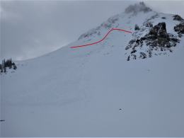
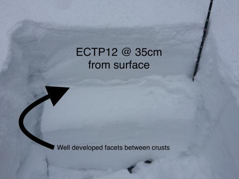
The snowpack in the Bridger Range is problematic. A layer of sugary, faceted snow a foot under the surface is weak. Without new snow and wind, the liklihood of triggering a slide is decreasing, but this layer is not getting stronger. Avalanches were triggered last week, skiers had a slope crack on Monday up Brackett Creek, and others had poor test scores (photo) by Frazier Lake. On Monday, Alex skied onto Saddle Peak and got this layer to break clean underneath a hard slab of dense snow. His video illustrates the poor snow structure he found in his snowpit. Avalanches are still possible so be extra careful traveling in avalanche terrain. A slide involving a hard slab would be deadly. For today, the avalanche danger is rated MODERATE.
The mountains outside Cooke City had avalanches during and after Sunday’s 2 feet of new snow and strong wind (avalanche activity details). Some avalanches broke just from the weight of the new snow while others avalanched on a thin layer of facets. Ian and I investigated this area on Monday and found this layer buried 1.5 feet deep and concluded it would not remain a problem for long (video, photo). Yesterday skiers south of town dug a pit and found good, stable conditions on their tour. Even so, given the weekend’s new snow, wind-loading, and variable nature of this weak layer, it is still possible to trigger slides. Travel one at a time in avalanche terrain and back off at the first sign of instability (cracking, collapsing and recent avalanches no matter how small). For today, the danger is rated MODERATE.

The northern Gallatin Range is an island of stability in our forecast area. In Hyalite, climbers reported stable conditions as they ascended steep gullies of snow. This mirrors my assessment from the weekend. Weak, faceted snow can still be found on slopes where the snowpack is thin, but these areas are isolated and triggering avalanches is unlikely. For today, the avalanche danger is rated LOW.
If you get out, please send us your observations no matter how brief. You can fill out an observation form, email us (mtavalanche@gmail.com), leave a VM at 406-587-6984, or Instagram (#gnfacobs).
Upcoming Avalanche Education and Events
Our education calendar is full of awareness lectures and field courses. Check it out and plan to attend one or two: Events and Education Calendar.
BOZEMAN
TONIGHT!! December 11, 1-hr Avalanche Awareness, 6-7 p.m. at REI.
December 12, Avalanche Awareness + Beacon Practice, 6-8 p.m. at Story Mill Community Center.
December 18, 1-hr Avalanche Awareness, 6-7 p.m. at Uphill Pursuits.
COOKE CITY
Every Friday and Saturday, Snowpack Update and Rescue Training. Friday, 6:30-7:30 p.m. at the Soda Butte Lodge. Saturday anytime between 10-2 @ Round Lake.
BILLINGS
December 17, 1-hr Avalanche Awareness, 6-7 p.m. Elevated Powersports.
CHOTEAU
December 19, 1-hr Avalanche Awareness, 7-8 p.m. at Choteau High School.
Sadly, in Colorado a skier was buried and killed in an avalanche on Sunday (Dec 8). This is the first avalanche fatality this season in the U.S. CAIC preliminary report.