Good Morning. This is Alex Marienthal with the Gallatin National Forest Avalanche Forecast on Monday, March 16th at 7:00 a.m. Today’s forecast is sponsored by Beartooth Powder Guides and Montana State Parks.
*** Bridger Bowl Ski Area is closed for the season. Backcountry conditions exist. There is no avalanche control or ski patrol services. Please stay clear of workers, work areas, snow cats, snowmobiles, chair lifts and other equipment.
At the end of the storm yesterday the mountains received 4-6” near West Yellowstone, Big Sky and Cooke City with 2” in Hyalite and the Bridger Range. Yesterday wind was southwest-west at 5-15 mph with gusts to 30 mph. This morning temperatures are teens to low 20s F and wind is 0-10 mph out of the west-southwest. Today, wind will shift west-northwest at 5-10 mph with temperatures reaching high 20s to low 30s F. Skies will clear near Bozeman and Big Sky with cloud cover more likely to the south, and no snow expected.

All Regions
Yesterday’s storm favored the mountains near West Yellowstone and Cooke City with 12-14” of new snow equal to 1.2-1.6” of snow water equivalent (SWE). The mountains near Big Sky got 9” equal to 0.9” SWE. In Hyalite and the Bridger Range a cold east wind limited snowfall to 4” (0.4” SWE). Yesterday near Cooke City skiers reported widespread natural slab avalanches breaking 6-12” deep within the storm snow (photo, details), and a snowmobiler triggered a slide a foot deep and a hundred feet wide (details). Doug skied in Beehive Basin and saw minimal wind loading and the new snow was bonding well (video, photo). Today the stability of the recent snow will be subject to change due to possible intense sunshine and near freezing temperatures. Where the snow surface gets wet loose snow and slab avalanches will become easy to trigger and could run long distances.
Anticipate decreasing stability on slopes that receive direct sun. Plan to be off of and out from underneath steep sun-exposed slopes before you see signs of instability like roller balls or natural loose snow avalanches. Ride on slopes that are sheltered from the sun and have a dry snow surface. Before riding steep slopes carefully assess the stability of the new snow by doing a stability test or watch for cracking of the snow surface or slides on small test slopes.
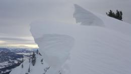
Wind is light and fresh drifts are not widespread, but remain cautious of slopes where slabs formed from east and southwest wind yesterday. Cornices get closer to breaking each day with weight from new snow or decreased strength from warmth and sunshine (photo). Stay far back from the edge of ridgelines and avoid slopes directly below large cornices.
Today recent snow makes avalanches possible and avalanche danger is MODERATE. Although many places are becoming deserted, the backcountry stays full of skiers and riders. Be on the lookout for each other. Stay diligent with snowpack and terrain assessment, and take precautions for avalanches like you did all winter. Ride Safe.
If you get out, please send us your observations no matter how brief. You can fill out an observation form, email us (mtavalanche@gmail.com), leave a VM at 406-587-6984, or Instagram (#gnfacobs).
Upcoming Avalanche Education and Events
Our education calendar is full of awareness lectures and field courses. Check it out and plan to attend one or two: Events and Education Calendar.
Remember Bridger Bowl has serious avalanche terrain. There is no longer ski patrol services and there is non-controlled avalanche hazard like the rest of the backcountry. Treat it accordingly. Carefully asses snow stability and consequences of all terrain you plan to travel in. The north bowl road is a terrain trap that gets hit by natural and skier triggered avalanches regularly. It is one example of not a good place to spend time walking up or standing.